For too long, discussions about hydrographic surveying methods have centered on comparing and contrasting individual technologies – multibeam vs. lidar, lidar vs. satellite, satellite vs multibeam. This “either/or” and one vs the other mentality is outdated. Each of these methods, whether using sound, light, or reflectance, is an imperfect tool for measuring a complex environment. Instead of debating the merits of one approach over another, we need to embrace a “both/and” strategy. The future of hydrography lies in intelligent integration, seamlessly combining diverse technologies for maximum efficiency, cost-effectiveness, and environmental responsibility. This article argues for a paradigm shift: moving from sequential, siloed approaches to a holistic, vertically integrated model that leverages the unique strengths of each technology.
Read on Hydro International
The Inefficiency of the Status Quo:
Current practices often fall short. We see examples of operational inefficiencies: lidar flights over remote islands without prior weather or water condition checks via readily available or tasked satellite imagery; repeated topobathy lidar reflights for small areas easily filled by satellite data; small vessel surveys in coastal zones running aground on unsurveyed shoals – all preventable with integrated approaches. Even in regions with open data policies, the time lag between data collection and availability can be significant, especially given the rate of environmental change. These operational gaps are not just inconvenient; they often represent wasted taxpayer dollars and missed opportunities for enhanced safety. A cost-focused argument demands that we maximize the value of every survey, prioritizing operational efficiency and focusing on desired outcomes, not simply sensor-based specifications.
A Vision for Integration:
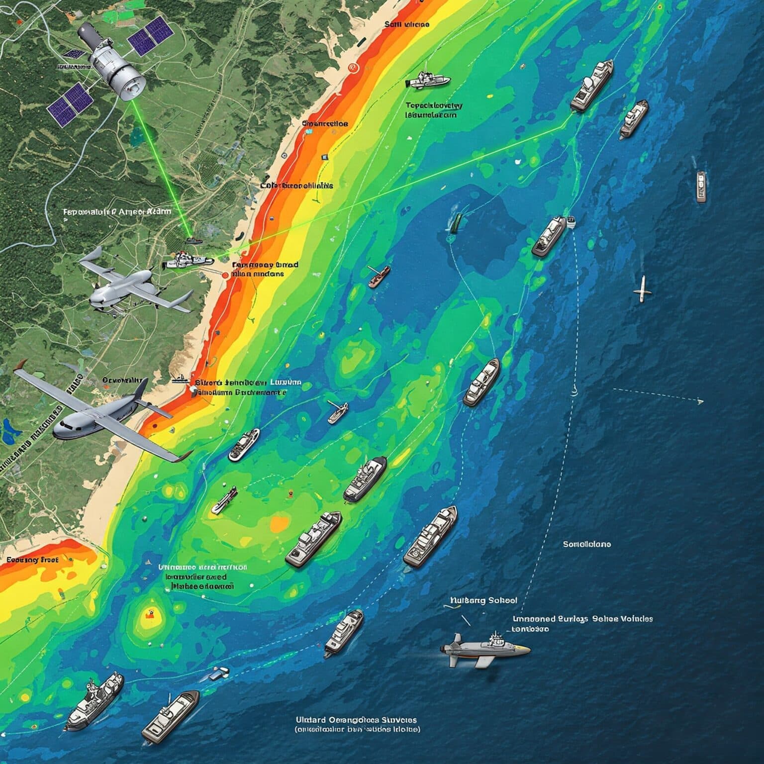
Imagine a hydrographic workflow where satellite-derived bathymetry (SDB) informs and improves topobathymetric lidar acquisition, identifying optimal flight times based on daily water clarity trends, minimizing reflights. SDB then serves as a planning tool for multibeam surveys, optimizing track lines and enhancing safety by highlighting potential hazards. This integrated approach is not just theoretical. We see promising examples like Land Information New Zealand’s (LINZ) forward-thinking approach in New Zealand, mandating water condition tracking to optimize bathymetric lidar collection.
The hydrographic landscape is transforming, and integrated hydrography is no longer just a vision; it’s a necessity.
Kyle Goodrich; TCarta President & Founder
SDB and other Earth Observation (EO) data also have use as the geospatial “glue” connecting land and sea, bridging the intertidal zone and providing a valuable baseline for higher-resolution data. A recent example of this approach can be seen on NOAA’s Office for Coastal Management (OCM) with an example of high resolution topobathymetric models with SDB included at the coastline, bridging the gap between hydrographic data and topography in a challenging location for coastal mapping: Alaska.
This integration extends into unmanned vessel data acquisition. SDB can de-risk USV operations through mission planning and hazard avoidance. The technology exists today for satellite-derived electronic charts to provide reconnaissance for a USV operating in remote islands in the Pacific Ocean with digital chart information delivered via space-based high speed internet.
Reversing the situation, information from lidar collection and in situ measurements from field operations can inform and improve SDB models, creating a powerful feedback loop for continuous improvement. USVs can provide valuable in situ for validation of SDB surfaces where other means are not available. This is technology integration: a full stack of sensors, from satellites in space to underwater vehicles and seafloor devices, focused on a challenging problem: mapping and characterizing the ocean floor and coastal zone.
Overcoming Barriers and Embracing the Future:
Several barriers or disincentives hinder widespread integration. Government RFQs and framework contracts often contract out individual survey technologies separately, discouraging integrated solutions. The biggest obstacle may be mindset. We must move beyond the “either/or” thinking and recognize the synergistic potential of integrated approaches. This requires a shift in RFPs and framework processes, requiring integrated solutions and focusing on the best approach for the specific location, not just a pre-determined platform or survey method.
The rise of the blue economy, with its increasing emphasis on environmental monitoring, further strengthens the case for EO in coastal mapping. With advancements like wave kinematic bathymetry, space-based lidar’s well-proven capabilities, and the development of high-resolution customizable hyperspectral satellites, the future of satellite-based hydrography itself is multi-modal and one of integrated techniques. Perhaps that is what draws ‘future hydrographers’ and next generation ocean explorers to the alternative hydrographic method of satellite based surveying.
Parting Thoughts:
The hydrographic landscape is transforming, and integrated hydrography is no longer just a vision; it’s a necessity. By combining the strengths of diverse technologies – from SDB and lidar to multibeam and USVs – we can unlock unprecedented levels of efficiency, cost-effectiveness, and environmental stewardship. This integrated approach isn’t just about better data; it’s about a deeper understanding of our oceans and a commitment to a sustainable future. Recent industry developments, such as the acquisition of a leading satellite-derived bathymetry and Earth observation company by the world’s largest hydrographic survey firm, signal a clear trend: the future of hydrography is vertically integrated. Earth observation is no longer a niche technology but a core component of modern hydrographic solutions. This acquisition validates the growing importance of SDB and EO and underscores the value of integrated services for an “all-sensor” approach. To further accelerate this evolution, my company encourages collaboration and partnerships in this arena. It’s time to move beyond “either/or” and embrace the power of “all of the above and below,” working together to shape the future of hydrography.