By: Dr. Chris Ilori
In the vast expanse of our changing world, regions where the waters remain largely uncharted are increasingly traversed due to the shifting tides of climate change and global trade. The Arctic, with its melting ice and expanding maritime activity, exemplifies the pressing need for accurate bathymetric data. Amidst this uncharted territory, the power of Satellite-Derived Bathymetry (SDB) emerges as a ray of hope, offering a solution to navigate these waters safely and sustainably. At TCarta, we live by the “Mind the Gap” philosophy, striving to bridge the divide in our understanding of remote environments such as the Arctic. This blog explores the potential of SDB, with a special focus on the innovative Radiative Transfer Model (RTM) methodology and its capability to map depths in areas that conventional mapping techniques have yet to uncover.
Mind the Gap in Navigational Safety Amidst Rising Maritime Traffic
Utilizing satellite data to measure and model the depths of water bodies, SDB offers an efficient and effective means for charting shallow coastal waters, a task increasingly vital along Canada’s extensive coastline—the longest in the world. This feature places Canada at the forefront of maritime navigation challenges, especially in the Arctic, where the logistical hurdles and costs of traditional survey methods are amplified by the harsh environment and the vast distances involved. The consequences of inadequate mapping in such expansive and ecologically sensitive regions can be severe. Ship groundings, a direct result of navigational errors, risk disastrous outcomes including environmental damage, loss of life, and significant economic tolls. Such incidents can disrupt vital shipping routes, necessitate costly rescue operations, and lead to severe penalties. Moreover, the Arctic’s delicate ecosystem faces threats from potential oil spills, with far-reaching effects on marine life and the livelihoods of Indigenous communities. Precise and comprehensive mapping, therefore, is not just a matter of enhancing maritime safety but also about adopting a proactive stance towards environmental conservation.
Mind the Mind the Gap in Bathymetric Mapping Methods
RTM has transformed the field of bathymetric mapping, especially in challenging regions like Hudson Bay where traditional in-situ data collection is scarce. It employs a physics-based approach grounded in radiative transfer theory to simulate how light interacts with the marine environment. This process is critical for translating satellite imagery into accurate bathymetric data and involves two primary steps:
- Generation of a Look-Up Table (LUT): The first step in the RTM process involves creating a Look-Up Table (LUT) of remote sensing reflectance (Rrs) spectra, which are a product of atmospheric correction and serve as a major input into an RTM. The table also includes all possible combinations of water column optical properties (absorption and backscattering coefficients) and the seafloor reflectance of the area being mapped.
- Inversion Process: Following the creation of the LUT, the inversion process begins. This step involves comparing the observed Rrs from satellite imagery against the simulated scenarios within the LUT to identify the closest match. By employing techniques such as least squares matching, this comparison allows for the retrieval of precise bathymetric parameters, including water depth and seafloor characteristics, specific to each image pixel.
Mind the Gap in Advancements: Recent Progress in RTM-based SDB at Hudson Bay
In exploring RTM’s application for bathymetric mapping, advances in SDB, especially in Hudson Bay, highlight RTM-based SDB’s potential. This region has hosted pioneering research, including the first Canadian application of RTM-based SDB. The initial study achieved a mapping depth of up to 4.5 meters with an RMSE of about 1 meter, noting atmospheric correction challenges. A scientist involved in both this foundational work and recent RTM projects at TCarta in Hudson Bay provides continuity. This expertise has refined our approach to atmospheric correction, essential for precise bathymetric mapping
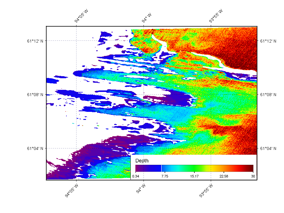
Recent efforts have extended mapping capabilities to 20 meters, although Crowd Sourced Bathymetry (CBS) used for validation reaches only 11.9 meters. The RMSE for these mappings is around 1.2 meters, reflecting the commitment to accuracy. This project aims to compare RTM-derived SDB data with CSB from the area to ensure accuracy and reliability. The SDB map below (Figure 1) shows where our RTM methodology has been applied in Hudson Bay. It illustrates the progress and highlights the effectiveness of RTM-based SDB. This continuity significantly informs our approach to atmospheric correction, pinpointing it as a critical link.

Overcoming Atmospheric Correction Challenges
The advancements in Hudson Bay reflect a concerted effort to refine the accuracy of atmospheric correction. Tackling historical challenges head-on, such as the ‘plane parallel assumption’ and the unique difficulties presented by low sun elevation in northern latitudes, TCarta has developed strategies to refine the RTM process. These improvements mark a significant leap in our ability to precisely adjust for atmospheric influences, improving the quality of SDB products. This adjustment in RTM, tailored to fit the specific atmosphere in Hudson Bay, demonstrates the progress achieved. It not only addresses previous limitations but also establishes a new standard for RTM-based SDB in challenging environments. The dedication to enhancing atmospheric correction underscores the essence of our “Mind the Gap” philosophy, bridging past gaps with present advancements.

