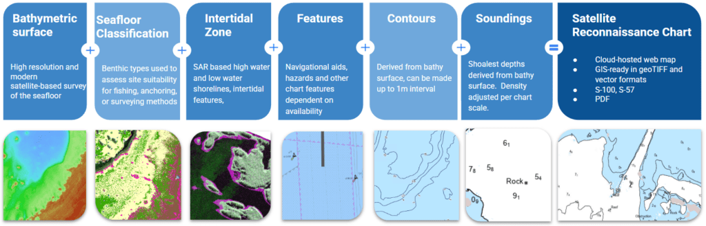
Satellite Reconnaissance Chart (SRC)
TCarta’s Satellite Reconnaissance Chart (SRC) fills an ever growing gap.
Across much of the globe, accurate and updated hydrographic data remains a rarity, forcing mariners to navigate poorly charted waters. Supplementary data is essential in such areas to improve hydrographic planning, reduce the risk of groundings, and equip mariners with reliable information.
Satellite Derived Bathymetry (SDB) is deployed to remotely survey coastal and nearshore areas, offering high resolution and up-to-date bathymetry to depths of 20m and up to 30m under ideal conditions. TCarta’s Satellite Reconnaissance Chart integrates familiar chart features such as soundings and contours onto an SDB-informed basemap for a complete, up-to-date hydrospatial perspective. When used in conjunction with a nautical chart, a Satellite Reconnaissance Chart can provide crucial detail to mariners and survey planners alike.
TCarta’s Experience Builder
Check out TCarta’s Experience Builder showcasing an SRC in Fiji, along with Seafloor Classification (SFC) and the source imagery from Maxar WorldView satellites
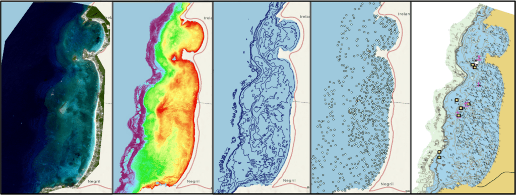
Rapid ArcGIS Pro Workflow: from Satellite Image to Reconnaissance Chart
The process begins with a high-resolution satellite image, from which Satellite-Derived Bathymetry (SDB) is extracted. Contours are then generated from the SDB surface, providing detailed elevation profiles. By integrating digitized nautical chart points, the data is refined to produce a comprehensive Satellite Reconnaissance Chart, offering enhanced hydrospatial insights for marine and coastal applications.
SRC Product Specifications
Discover the power of TCarta’s Satellite Reconnaissance Chart—delivering high-resolution, up-to-date hydrospatial data for informed decision-making and enhanced project planning. Leverage advanced satellite technology to gain critical insights tailored to your needs. Contact us today to learn more and see how our solutions can support your mission!
Fill out the form to get in touch with us
