• Skip to primary navigation
  • Skip to main content
TCarta Satellite-Based Hydrospatial Tech

TCarta Satellite-Based Hydrospatial Tech

We are your contact for Marine Remote Sensing and Hydrospatial data services.

  • Who We Are
    • About
    • Partnerships & Affiliations
  • What We Do
    • What is Hydrospatial?
    • What Do We Measure?
    • How to Work with TCarta
  • Products & Services
    • Products
      • Global Bathymetry GIS
      • Satellite-Derived Bathymetry
      • Seafloor Classification
      • Newsletter Archive
      • Marine Basemaps
    • Services
      • Blue Carbon Mapping
      • Synthetic Aperture Radar (SAR)
      • Satellite-Derived Water Quality
      • Trident Tools Satellite-Derived Bathymetry Software
    • Custom Solutions
  • Case Studies
    • Space-based Hydrospatial Solutions for Engineering Projects in the Littoral Zone
    • Technology Demonstration Project: Large-Scale Satellite Derived Bathymetry Mapping
    • Hydrographic Office Technology Integration
    • Updating Information on Nautical Charts in Baffin Island, Canada
  • News & Press
    • Newsroom
    • Blogs
  • Product Viewer
  • Contact
  • Show Search
Hide Search

Arctic

Connecting Remote Communities: Providing Up-to-Date Data with Satellite-Delivered Bathymetry

TCarta Marine · March 3, 2025 ·

By: David Bautista

Coastal zones have always been an attractive extent for human settlements, providing plenty of natural resources and economic advantages. This interface between land and sea provides multiple benefits, including commerce, trade and transportation, marine resources, and tourism. 

Unfortunately, settlements in far-away and isolated regions face diverse environmental and social challenges. Limited access to health, supplies, and education services; demographic changes affecting the available labor force such as out-migration; higher costs of living; high reliance on natural resources for sustenance; and extreme weather conditions are some examples. 

The effects of global warming also have a major impact on those communities, particularly in the Arctic and Subarctic regions. Remote coastal communities are more vulnerable to environmental and socio-economic impacts of climate change, including coastal flooding, shoreline erosion, saltwater intrusion, habitat loss, and threats to economic activities (fishing, harvesting, and tourism).

There is a greater need for accurate and up-to-date information, especially to understand the morpho-hydrodynamic behavior of coastal areas (seasonal changes in erosion, and transport of sediment and deposition). Monitoring these very dynamic natural systems is thus of great importance for supporting remote communities as well as the conservation of natural resources.

For this reason, governments step in to support adaptability and resilience, and adequate levels of connectivity. Bathymetry with high spatiotemporal resolution is the primary and essential input for understanding the dynamics of coastal systems. However, traditional survey methods, such as multibeam echosounder (MBES) ship-borne, Light Detection and Ranging (LiDAR) airborne, and ground-based are not the most suitable techniques for addressing these concerns.

Traditional survey methods (MBES and LiDAR) provide very high resolution with fine vertical accuracy. However, these techniques face economic and logistic constraints, as well as challenges to map large areas relatively quickly. Thus, Spaceborne Remote Sensing techniques represent an efficient and cost-effective method for mapping remote and hazardous environments. 

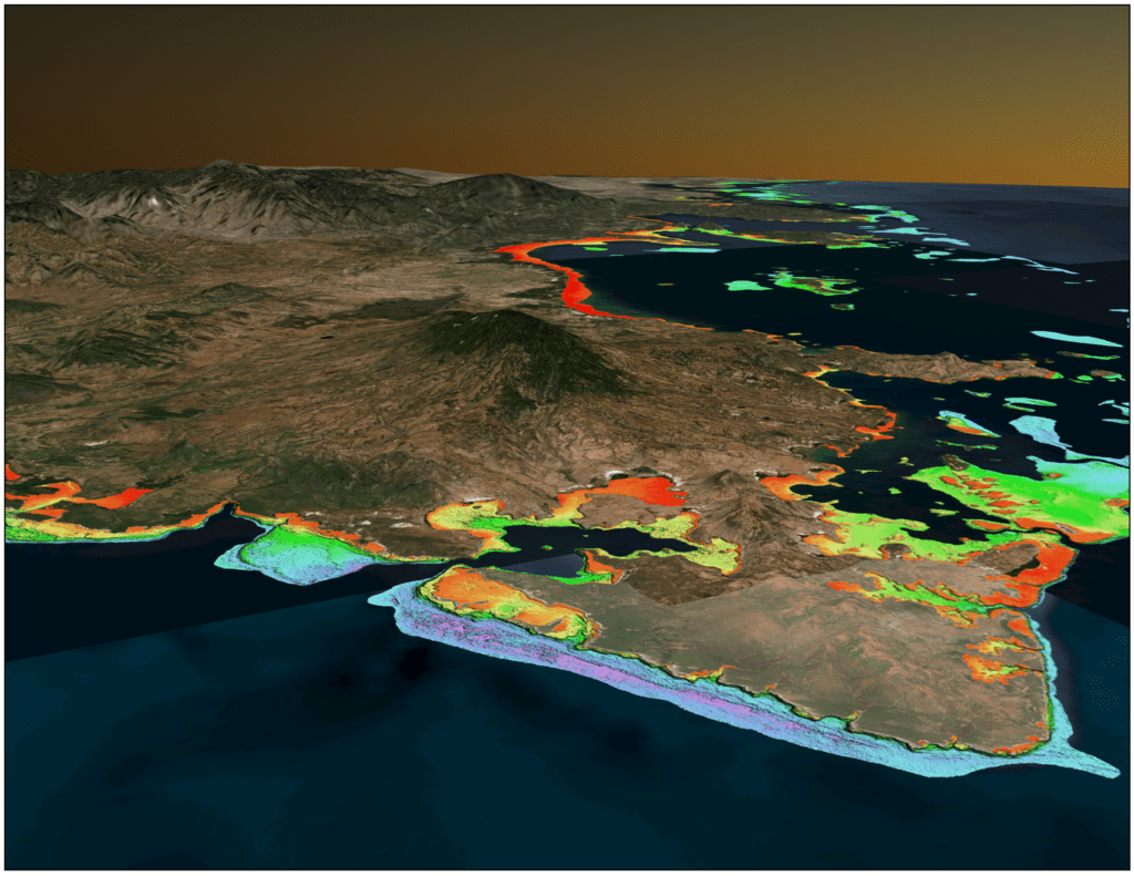
Satellite Derived Bathymetry (SDB) can return seafloor depths using spaceborne sensors, such as Sentinel-2, LandSat, Pléiades, WorldView, GeoEye, Planet, and Capella SAR. SDB provides low-cost and un-intrusive solutions with the ability to map changes over time in large remote areas. As a result, SDB is considered to be an overly appropriate alternative to provide data acquisition in remote communities. SDB can be a cost-effective and efficient way to fill in data gaps, support safe navigation (updating nautical charts data in the coastal waters), and enhance the understanding of the marine environment.

10m SDB over Inukjuak, QC, Canada

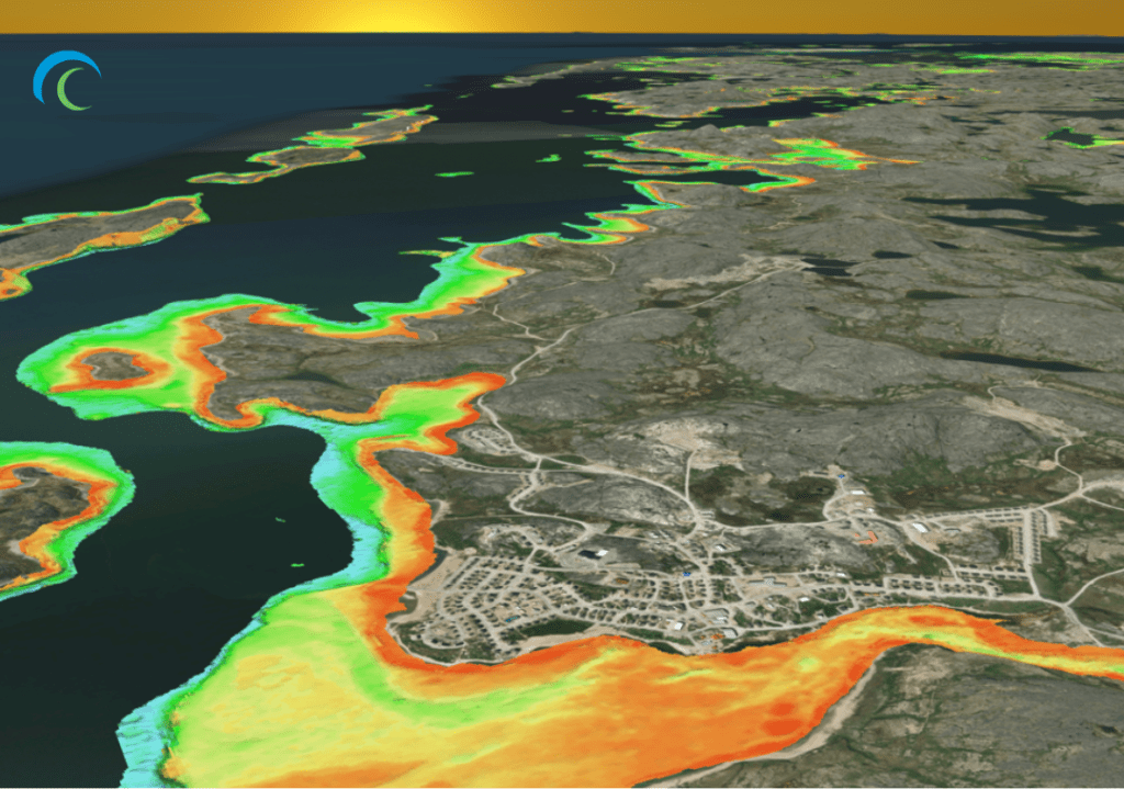
Through a Canadian Hydrographic Service (CHS) contract and with IIC Technologies as Prime Contractor, TCarta facilitated 10m SDB datasets in the waters around Inukjuak and Ulukhaktok, Canada.

Inukjuak is a remote, traditional Inuit community located in Nunavik, Northern Quebec, Canada, with more than 1,500 people bordering the Hudson Bay. The region is influenced by the Southern Arctic conditions and characterized by a cold dry climate with a continuous permafrost. The mean annual temperature is -6ºC; cold conditions persist over long periods during winter (mid-November to March), where temperatures less than -15ºC persist and thaws are infrequent. Hudson Bay usually freezes by the end of December, near the coastline, and ice usually melts in late June or early July.

Ulukhaktok, another Inuit community with fewer than 500 inhabitants, is located on the west coast of Victoria Island, the second largest island in the Canadian Arctic archipelago and the ninth-largest island on Earth. There are prominent cliffs that line the shore, lowlands, and numerous ponds, lakes, and rivers. Seasons are weather and ice dependent. Summer is characterized by open water from early July to September; during fall (October through mid-November) sea ice freeze-up, and winter is characterized by frozen sea conditions. Speed and direction of the wind influence sea ice freeze-up and breakup.

Both communities are only reachable by plane, helicopter or boat. Its economy depends on hunting,  fishing, trapping, and gathering; hunters and fishers catch wildlife and fish from the waters and islands of Hudson Bay in Inukjuak and the coastal waters of Prince Albert Sound and Minto Inlet in Ulukhaktok.

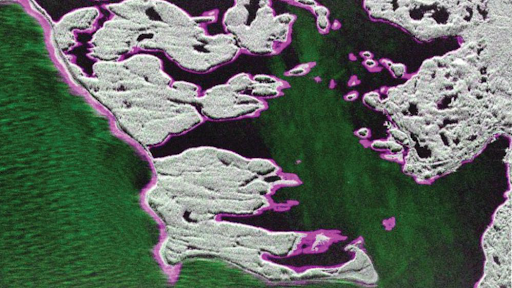
Understanding the importance and relevance of surveying all optically shallow water in these regions; TCarta deployed a hydrospatial survey with cutting-edge remote sensing techniques. The negative effects of local water column and atmospheric conditions were controlled using multi-temporal image composites. Sentinel-2 Level-1C imagery was selected, and a minimum of 100 singular atmospherically corrected images were statistically combined. The combination of multi-temporal images allowed to obtain the “best” pixels for SDB derivation.

TCarta successfully delivered 982.8 km² of SDB coverage, 855.2 km² in Inukjuak and 127.6 km² in Ulukhaktok. The efforts for this hydrospatial survey will benefit both communities with up-to-date data. Lastly, TCarta is pleased to announce how the produced SDB accomplished the overlaying goals of filling the gaps in coastal bathymetry, enhancing understanding of the marine environment (especially, the fact that its economy certainly depends on hunting and fishing, and filling data gaps supports such activities), and supporting safe navigation in the Canadian Arctic. This type of project exemplifies the necessity of state-of-the-art SDB technology in remote locations, and the capabilities of hydrospatial solutions.

Global Satellite-Derived Bathymetry

TCarta Marine · June 12, 2024 ·

New Satellite Sensors Continue to Improve Technique

—Read in Sea Technology—

In less than a decade, satellite-derived bathymetry (SDB) has evolved from a shallow-water mapping technology that could be applied only in clear, calm waters to one that can now be used cost-effectively and reliably in a wide variety of coastal environments around the globe. A 2023 project conducted in the challenging waters of Alaska was one of several that highlighted the arrival of SDB as a commercially viable, globally applicable seafloor mapping technique.

TCarta Marine of Denver, Colorado, successfully completed the Alaska project despite the presence of nearly every environmental condition that traditionally thwarted SDB production. The results were impressive: Seafloor depths were measured down to 26 m in Kachemak Bay and to 3 m in the murky and turbulent Arctic waters of Point Hope. Additionally, the data sets were delivered on time and within budget to the customer, NOAA’s Office of Coastal Management, and the data were made freely available to the public via the NOAA Digital Coast website: https://coast.noaa.gov/dataviewer/#/.

Fully appreciating the significance of this effort requires an understanding of SDB technology. It involves the analytical processing of the red, green, blue and infrared bands in optical multispectral satellite imagery. These spectral signatures captured by space-based sensors result from light energy penetrating the water column and reflecting off the seafloor. Processing these spectral reflectance values with specialized SDB algorithms calculates the depth of the water.

SAR-based intertidal zone mapping achieved with Capella Space satellites synchronized to capture imagery at high- and low-tide periods. Pink area indicates the intertidal zone in Yakutat, Alaska.

Numerous factors, however, can foil the SDB methodology. Darkness and cloud cover entirely prevent image collection by optical satellites, while the presence of sea ice and high levels of sediment or chlorophyll in coastal waters hinders light penetration, thereby eliminating seafloor reflectance and SDB derivation. The polar regions experience excessive cloudiness and six months or more without adequate sunlight for SDB. During summer months, glacial runoff creates highly turbid waters in addition to large-scale phytoplankton growth due to 24 hr. per day of light. Overall, the conditions for SDB in Alaskan waters are among the most challenging in the world. Despite these drawbacks, SDB is a popular mapping technique that has been applied reliably in many parts of the world and is a vital component to comprehensive coastal mapping programs. The primary benefit is that it can be used in shallow coastal zones that are too dangerous for shipborne methods, such as sonar, or too remote for deployment of airborne LiDAR.

Optical satellites, on the other hand, capture imagery globally across political boundaries and without risk to personnel, equipment, or the environment. The reduction in use of carbon-fuel-burning survey platforms is also a considerable benefit of satellite-based survey methods, and carbon costs are now becoming a consideration in international tenders for ocean mapping.

Geographic areas most amenable to SDB have traditionally included the Caribbean, Red Sea, Pacific atolls and the Arabian Gulf. Historically, SDB extraction from multispectral imagery was performed with one of two algorithms: Radiative Transfer or Band Ratio. The first is extremely computer intensive, sometimes taking days to process one image and requires extensive expertise. Band Ratio, on the other hand, is faster but requires calibration data, such as sonar or other direct depth measurement, which often aren’t available in remote or dynamic coastal zones, and high accuracy is limited due to areas of homogeneous seafloor.

The expansion of commercial SDB to parts of the world once thought impossible or impractical for it has resulted from a convergence of critical factors in just the past several years. These include dramatic improvements in satellite remote sensing capabilities, refinements in machine learning technologies to select images and derived water depths, and global availability of a secondary satellite-based bathymetric derivation method: space-based LiDAR.

The simultaneous emergence of these innovations has enhanced the quality and reliability of SDB measurements in places where it has always been applicable and expanded its technical viability to almost all environmental conditions and geographic locations. Just as importantly, the method can now be affordably applied in massive project areas, even if time and budgets are limited.

This is just the start of a paradigm shift in SDB methodology and applicability. There are additional advancements now being researched—mainly in the form of new satellite imaging technology—that will continue to enhance satellite-derived bathymetry.

Mapping the Alaskan Coastline

The success of the Alaska project would likely not have been possible if it weren’t for the research and development conducted under two Small Business Innovation Research (SBIR) grants awarded to TCarta by the National Science Foundation and NOAA between 2018 and 2022 with the goal of modernizing SDB techniques and expanding the pool of usable sensors. The research focused on overhauling the entire SDB workflow, devising tweaks to the algorithms themselves, as well as experimenting with new and better data imagery selection, data cleaning techniques and accuracy assessment.

The NOAA grant sought to specifically improve SDB outcomes in high-latitude areas such as Alaska and the Arctic. TCarta worked on the theory that notoriously turbulent coastal zones in this region experienced some calm days suitable for SDB. But pinpointing such ideal conditions that also coincided with periods of daylight dramatically narrowed the potential acquisition window of optical satellite image collection.

Fortunately, the availability of SDB-suitable imagery has exploded over the past 25 years with the launches of numerous optical imaging constellations. Gone are the days when the U.S. Landsat and French SPOT satellites were the only image sources, with imagery collected once a week at best. Today, there are numerous Earth observation systems in orbit operated by Maxar, Airbus, European Space Agency (ESA), Pixxel, Planet, Satellogic, and several others that provide a plethora of images to select from.

These satellites have been capturing imagery for years and amassing enormous archives of data covering the entire Earth. In many cases, these archives contain deep stacks of numerous images for each spot on the globe, some with hundreds of images to select from. In addition to more frequent acquisitions, some of these sensors capture reflectance data in different segments of the optical and infrared spectra, which enhance SDB by penetrating deeper into the water column, providing additional seafloor information and enabling more robust corrections for atmospheric distortions.

TCarta had been modifying the original SDB derivation algorithms with the addition of these new spectral bands and ratios of multiple bands and then applying machine learning to recognize the best results from the seafloor extraction process. It was a natural step to then apply machine learning to stacks of archived satellite images and find the ones with the clearest, calmest water conditions for SDB processing. From there, the process was refined to use machine learning to isolate and combine the best pixels from multiple overlapping images for derivation of water depths. Searching the archives manually to find images with the right characteristics would be impossible or too time consuming for practical application. Machine learning makes this possible.

For Alaska, TCarta processed high-resolution multispectral imagery from the Maxar and Planet archives to complete the project. These data sets were chosen for their high spatial resolution and frequency of imagery collection, which were required to meet the bathymetric accuracy requested by NOAA’s Office of Coastal Management. TCarta used a custom process to assimilate the radiometric measurements of the two different sensor systems for consistent SDB extraction.

Incorporation of machine learning into the SDB processing workflow has substantially reduced production time. TCarta routinely processes dozens to hundreds of images in the same time it would have taken for one just a few years ago. This has substantially improved the overall economics and viability of SDB as a commercial service.

Madagascar SDB produced and delivered to the Seabed 2030 global mapping initiative. Marine Institute of Memorial University of Newfoundland 2023 summer interns produced this country-wide data set using TCarta’s Trident Tools SDB software.

Adding Satellite LiDAR for Validation

The other major addition to the SDB workflow has been space-based LiDAR, or laser altimeter, data from NASA’s ICESat-2 satellite. Launched with the intent of measuring the thickness of sea ice, glaciers and tree canopies, the satellite also directly measures seafloor depth down to about 30 m under the right conditions. The LiDAR’s green laser emissions penetrate shallow water, reflect off the bottom, and return a signal to the sensor. The data can be processed to determine depth to high levels of accuracy.

The ICESat-2 measurements are made in single-point survey measurements with approximately 1 m between points along the track and with several kilometers between each track, which means the data cannot be used as a standalone bathymetric mapping tool for broad areas, but its value is still considerable.

ICESat-2 has proved to be the ideal validation and calibration data set that extends SDB utility to remote parts of the world where no control points can be collected or are otherwise unavailable from on-site methods. The ICESat-2 data are applied in two aspects of the modernized SDB workflow. The laser measurements are first employed as training data to train the machine learning algorithms to recognize water depths in optical imagery. The ICESat-2 points are also used to validate the accuracy of SDB calculations derived from the Radiative Transfer SDB method, enhancing the confidence in derived water depth values. By combining both methods and information from two satellites using independent methods for water depth derivation, greater confidence in the results is achieved.

Although TCarta uses the NASA data in all SDB projects now, the value of the data set was demonstrated most vividly in another 2023 project where TCarta performed bathymetric mapping of the entire Madagascar coastline. Mapping the coastal zone of the fourth largest island on Earth was noteworthy for several reasons, aside from its sheer size and remoteness. First, the project was supported by the Seabed 2030 program, which was also the recipient of the final products. Second, TCarta completed the SDB mapping in cooperation with students during a summer work term program at the Marine Institute (MI) of Memorial University in St. John’s, Newfoundland, Canada.

Due to a limited budget and grand ambitions to make large contributions to Seabed 2030, free imagery from the 10-m-resolution ESA Sentinel-2 satellite was used. Thousands of satellite images, many stacked over the same areas of interest, were obtained for the entire Madagascar coast. Without machine learning and ICESat-2, the SDB mapping project would have taken 12 months or more just a few years ago, but the student-involved teams completed it in a few weeks, achieving 24-m-deep measurements along the majority of the Madagascar coastline.

The technology and techniques developed under TCarta’s research grants have not only gone on to benefit the commercial and government projects, but also it has proven to be a tremendous instructional tool for future hydrographers and contributed significant data coverage to the global effort to map the entirety of the seafloor.

Seabed 2030 and Marine Institute of Memorial University of Newfoundland 2023 summer interns and facilitators. Plans for a 2024 (year two) intern program and data contribution to Seabed 2030 are underway.

The Future of SDB

The revolution in commercial imaging satellites has included two types of data collection systems that hold significant potential for SDB applications and supplemental coastal products. These are synthetic aperture radar (SAR) and hyperspectral satellite constellations. The primary advantage to SAR is that, unlike passive optical systems that capture reflected sunlight, radar sensors actively emit signals that can pass through darkness and clouds to bounce off the Earth’s surface and return data. This means they can collect data 24/7 anywhere on the globe. The key difference in recent SAR missions is their spatial resolution supports practical coastal mapping. Commercial SAR operators include Capella Space and Umbra in the U.S., ICEYE of Finland, and Synspective of Japan.

While SAR does not provide seafloor depth information due to lack of water column penetration, it does add important shoreline location data that can enhance SDB accuracy. TCarta has used the radar data collected at both day and night in some high-latitude projects to precisely map high- and low-tide water levels to determine the extent and characterization of the intertidal area. These shoreline features can be applied as a complement to the SDB products, but it is often requested by some commercial clients as a standalone coastal map product.

TCarta has teamed with Capella on joint research projects to determine other ways high-resolution SAR can be incorporated into marine mapping and possibly SDB projects. As an analytic partner, TCarta has been developing coastal products and tools for ready use by customers around the globe. The potential for hyperspectral satellite data to directly impact SDB by facilitating deeper and more accurate seafloor measurements is even more significant. Generally referring to sensors that acquire reflected data in more than 10 spectral bands, hyperspectral systems have recently been launched by several companies: Pixxel in India, Wyvern in Canada, Orbital Sidekick of the U.S. and others.

The excitement for SDB analysis is that these sensors capture reflected energy in very narrow bands across the visible and infrared portion of the spectrum. Initial research by TCarta in cooperation with Pixxel indicates these narrow bands, especially in visible green and blue, will detect reflected energy that has passed more cleanly through the atmosphere without distortion and penetrate deeper into the water column. This will potentially extend the useful range of SDB into deeper, and possibly less clear, water.

TCarta produced SDB in Teller, Alaska, which was integrated with multiple freely available data sources into a seamless topobathy digital elevation model.

While more advanced satellite imaging platforms will continue to play key roles in SDB progress, the SBIR grants from the U.S. government have most directly impacted shallow-water mapping capabilities for the hydrographic and hydrospatial communities. These investments are paying off in terms of safer coastal navigation, more responsible shoreline development, and more diligent environmental protection in the littoral zone.


Kyle Goodrich is the president and founder of TCarta Marine and has a 22-year career in geospatial services. Since founding TCarta in 2008, Kyle has led numerous geospatial product research and development plans, including the development and commercialization of satellite-derived bathymetry, stereo photogrammetric bathymetry, a global aggregation and assimilation of multi-source bathymetry data and global vector shoreline. As principal investigator in TCarta’s National Science Foundation and NOAA Small Business Innovation Research Phase Two projects and as an active industry member in international hydrographic commissions, Goodrich is a persistent and passionate leader in the commercialization of satellite-based marine remote sensing technologies.


You can also view this article on TCarta’s LinkedIn: https://www.linkedin.com/pulse/global-satellite-derived-bathymetry-tcarta-marine-ufmvc/?trackingId=ClUjZSlmjUmSmhTxUKXY3A%3D%3D

Back to newsroom

Shaping tomorrow’s ocean mapping education

TCarta Marine · June 10, 2024 ·

Canadian summer internship programme trains hydrographers of the future

Read in Hydro International

Three marine organizations teamed up in the summer of 2023 to prepare
Canadian ocean mapping students to become ‘hydrographers of the future’.
The first-of-its-kind internship programme focused on equipping the students with the technical skills and knowledge that are increasingly required in the hydrography profession but are not yet taught in many college programmes because they are so new and evolving at such a rapid pace.

“The hydrographer of the future must still understand traditional marine science and ocean survey practices, but in addition will need training in automated marine and airborne sensor systems, satellite-based Earth observation platforms and artificial intelligence applications.” said Kyle Goodrich, president of TCarta Marine, the Colorado firm that spearheaded the programme.

Six undergraduate and two graduate students participated in the summer-long paid internship co-sponsored by, and held at, the Marine Institute (MI) of Memorial University in St. John’s, Newfoundland. All eight students were enrolled in the MI Ocean Mapping programme. Mobilization of the programme was shared among TCarta, Memorial University and The Nippon Foundation-GEBCO Seabed 2030 Project, which seeks to inspire the complete mapping of the seafloor by 2030.

“Field work will remain a key part of hydrography, but hydrographers will also have to be data scientists, ” said Paul Elliott, academic director and instructor in the MI Master of Applied Ocean Technology programme. “There is so much data being collected from many different technologies, and hydrographers must know what to do with it.”

Interns surveyed the entirety of Madagascar, producing 14,555 square kilometers of ten-metre resolution SDB from Sentinel-2 multi-image composites via an ICESat-2 informed machine learning method. The complete Madagascar dataset was submitted to Seabed 2030

Another objective of the internship was to make hydrography more attractive as an academic pursuit and profession at a time when the need for trained ocean mappers is expanding. This demand is being driven by increased offshore hydrocarbon exploration, renewable energy siting and coastal development, all of which require detailed seafloor mapping.

The reactions from the students on completion of the hands-on course were overwhelmingly positive. Each had a slightly different experience, but the most common takeaways were excitement about acquiring additional employable skills, surprise at discovering new facets of the hydrography profession, and enthusiasm in playing a part in the Seabed 2030 initiative. “I’ve definitely learned skills that I otherwise wouldn’t have learned in the classroom,” said Kaitlin Power, a third-year MI Ocean Mapping student.

The Seabed 2030 sponsored summer intern program included six undergraduate students and two graduate students of the Ocean Mapping programme at the Fisheries and Marine Institute of Memorial University of Newfoundland.  Pictured from left to right:Venkata Yadavalli, David Bautista, Michaela Barnes (Marine Institute alum and general manager, TCarta), Remy Ouellet, William Edwards, Kaitlyn Power, Maggie Lewis, Jenna Ryan, Kyle Goodrich (president and founder, TCarta) and Amanda Steele.

The internship delivered these experiences in a real-world work environment. Spending eight-hour days in the MI computer laboratory, the students received traditional instruction from TCarta personnel followed by intensive collaborative work on seafloor mapping projects. Some datasets were delivered to TCarta customers as commercial products, while others were provided to Seabed 2030 for inclusion in the global GEBCO grid.

Instruction in integrated technologies

The 2023 curriculum focused on training the students in the application of satellite derived bathymetry (SDB), a technique that derives seafloor depth in shallow water, usually in coastal zones, through analysis of multispectral satellite imagery. SDB served as an ideal instructional tool because it integrates multiple state-of-the-art technologies, many new to hydrography. “SDB fills the gap in shallow-water data collection where it’s too risky to operate traditional bathymetric survey technology,” said Elliott.

Dating from the days of the U.S. Landsat mission in the 1970s, SDB is a less expensive and safer method of measuring bathymetry in the near-shore environment than traditional shipborne, or even airborne, techniques. SDB achieved mainstream status in 2020 when the U.S. National Oceanic and Atmospheric Administration (NOAA) and the UK Hydrographic Office adopted the technology as an official hydrographic survey method. Numerous international ocean mapping agencies followed. In 2021, Seabed 2030 specifically requested SDB data as a cost-effective technique for near-shore mapping.

Over the past decades, the quality of SDB mapping increased as spatial resolution of satellites improved, although the core processing algorithms remained the same. It was widely agreed that the technology needed an overhaul. TCarta applied for funding from NOAA and the National Science Foundation to upgrade the entire SDB workflow with state-of-the-art processing capabilities and expand its applicability to deeper, murkier waters, especially in Arctic regions.

Through the SDB training, the interns were introduced to dozens of new technologies and skills, some that are outside the typical course curricula for most hydrography students. Although technologies such as satellite imaging and artificial intelligence may be unique to the SDB workflow for now, TCarta is confident that they will soon be integrated into other ocean mapping methodologies.

Key capabilities

Students were taught many key capabilities during the summer. For instance, they were introduced to the variety of satellite imagery available for SDB and studied the strengths of each for certain project types. For example, no-cost coarse-resolution ESA Sentinel-2 A/B satellite data was used for broad geographic coverage, while high resolution Maxar WorldView imagery was processed for targeted, site specific applications.

TCarta also instructed the interns on how to use a pre-processing tool to prepare in situ data from sonar or Lidar as calibration datasets for processing the satellite images. Furthermore, they learned how to apply an enhanced version of a traditional band ratio algorithm along with a newly devised machine learning random forest algorithm in iterative processes to derive water depth measurements from individual image pixels.

Another capability taught was how to harness the power of cloud computing to apply the SDB algorithms to stacks of multi-temporal Sentinel images acquired for the same location at dozens of different times. The interns also used an artificial intelligence-based QA/OC tool to apply Lidar data from the NASA ICESat-2 satellite to evaluate and validate the SDB outputs. FMABE 3D point cloud software developed by the U.S. government was also employed to edit hydrograpnic datasets to produce final deliverables.

“Having these skills puts us at an advantage over other students who will be looking for work in the future,” said Maggie Lewis, also a third-year ocean mapping student.

Creating real world products

For Will Edwards, an MI Ocean Mapping student, part of the internship’s attraction was working on SDB products that would be deliverables for real end users, especially the Seabed 2030 endeavour, which is considered the highest profile seafloor mapping project in the world right now. “I am really happy to get the opportunity to provide data to Seabed 2030…I had been waiting a few years to do that,” said Edwards. “I’m glad the data [we produced] was accurate enough to be used.”

“The SDB datasets provided by the students of the summer internship are instrumental in supporting the global effort underway to deliver a complete map of the ocean floor by 2030,” said Seabed 2030 Director Jamie McMichael-Phillips. “We are delighted to support this collaborative internship co-sponsored with our partners Memorial University and TCarta, enabling students to acquire cutting edge hydrospatial skill sets and equipping them for their future careers as modern hydrographers.”

In total, the interns created more than 21,125 square kilometres of SD coastal products during the 12-week session. Key datasets included:
• the entire Newfoundland coastline and three Arctic regions for MI research;
• Timor Island in Asia and New Hanover Island in Papa New Guinea for Seabed 2030; and
• the entire Madagascar coastline off the coast of Africa for a TCarta client.

“The students took what they learned in the classroom and applied it to real projects with actual data and deadlines. They learned what they have to do to get a project completed,” said Elliott. “They therefore know what will be expected from them when they join the workforce.”

MI’s success at educating hydrography students has put it at the top of ocean mapping programmes worldwide. The Master’s programme has been recognized by the International Hydrographic Organization as one of the few to receive the
S-5A standard of competence.

TCarta SDB summer interns learned and deployed an entire suite of SDB skills and workflows, including ICESat-2 selection for calibration and validation, SDB production and evaluation using multiple tools and resources such as nautical charts, and 3D point cloud editing.

Success and what’s next

The internship programme succeeded on many levels. Among the most important was resetting the students’ expectations of what a future career in hydrography might look like. MI hydrography instructor, Olga Telecka, explained: “Hydrography has traditionally been a profession in which most data collection work was conducted on a ship. For many, the prospect of spending weeks or months on a boat away from home eliminated hydrography as a professional choice. But now that so much data is being collected remotely and with data analysis being performed in onshore labs, the profession offers opportunities for both maritime enthusiasts and land lovers.”

“What [the students] learned in the internship is that hydrographers don’t necessarily need to go on a vessel to have a career in this industry, which for some is very important,” continued Telecka. “This programme opens the horizon.”

Telecka added that for MI, the course reinforced the value of academic-industry partnership. Working professionals can expose students to cutting edge technologies already being used in the commercial world before they find their way into textbooks. Based on the positive experience with TCarta, MI is considering other technologies to feature in future internships.

TCarta is working closely with MI to refine the SDB programme and sponsor it again next summer. “The programme showed us that a non-distracted group of new-to-SDB people could take a new technology in a short time period and produce solid, professional work – as students,” said TCarta’s Goodrich. “The students performed better than we anticipated, impressing us with their eagerness and interest in improving the new processes they were learning.”

The internship organizers hope that the internship format will provide a template for other academic programmes and private sector companies to introduce hydrography students to the latest technologies, helping them to understand the full breadth of the profession and making it more appealing in the process. While the internship succeeded in preparing students to become hydrographers of the future, Goodrich noted, the hydrography industry still has much work to do in attracting more students to the discipline. He challenges private sector colleagues and academics to do more in promoting hydrography and ocean mapping to young people long before they reach university.

For universities, the key is collaboration. MI’s Elliott recommended that academic institutions look for partners in the commercial world to partner with, as his did with TCarta to help make the transition to the working world easier for the students.

About the author: Kevin Corbley is a business development consultant with more than 30 years of experience in the geospatial profession. He is based in Colorado, USA.

Back to newsroom

Minding the Gap in Uncharted Waters

TCarta Marine · April 11, 2024 ·

By: Dr. Chris Ilori

In the vast expanse of our changing world, regions where the waters remain largely uncharted are increasingly traversed due to the shifting tides of climate change and global trade. The Arctic, with its melting ice and expanding maritime activity, exemplifies the pressing need for accurate bathymetric data. Amidst this uncharted territory, the power of Satellite-Derived Bathymetry (SDB) emerges as a ray of hope, offering a solution to navigate these waters safely and sustainably. At TCarta, we live by the “Mind the Gap” philosophy, striving to bridge the divide in our understanding of remote environments such as the Arctic. This blog explores the potential of SDB, with a special focus on the innovative Radiative Transfer Model (RTM) methodology and its capability to map depths in areas that conventional mapping techniques have yet to uncover.

Mind the Gap in Navigational Safety Amidst Rising Maritime Traffic

Utilizing satellite data to measure and model the depths of water bodies, SDB offers an efficient and effective means for charting shallow coastal waters, a task increasingly vital along Canada’s extensive coastline—the longest in the world. This feature places Canada at the forefront of maritime navigation challenges, especially in the Arctic, where the logistical hurdles and costs of traditional survey methods are amplified by the harsh environment and the vast distances involved. The consequences of inadequate mapping in such expansive and ecologically sensitive regions can be severe. Ship groundings, a direct result of navigational errors, risk disastrous outcomes including environmental damage, loss of life, and significant economic tolls. Such incidents can disrupt vital shipping routes, necessitate costly rescue operations, and lead to severe penalties. Moreover, the Arctic’s delicate ecosystem faces threats from potential oil spills, with far-reaching effects on marine life and the livelihoods of Indigenous communities. Precise and comprehensive mapping, therefore, is not just a matter of enhancing maritime safety but also about adopting a proactive stance towards environmental conservation.

Mind the Mind the Gap in Bathymetric Mapping Methods

RTM has transformed the field of bathymetric mapping, especially in challenging regions like Hudson Bay where traditional in-situ data collection is scarce. It employs a physics-based approach grounded in radiative transfer theory to simulate how light interacts with the marine environment. This process is critical for translating satellite imagery into accurate bathymetric data and involves two primary steps:

  • Generation of a Look-Up Table (LUT): The first step in the RTM process involves creating a Look-Up Table (LUT) of remote sensing reflectance (Rrs) spectra, which are a product of atmospheric correction and serve as a major input into an RTM. The table also includes all possible combinations of water column optical properties (absorption and backscattering coefficients) and the seafloor reflectance of the area being mapped.
  • Inversion Process: Following the creation of the LUT, the inversion process begins. This step involves comparing the observed Rrs from satellite imagery against the simulated scenarios within the LUT to identify the closest match. By employing techniques such as least squares matching, this comparison allows for the retrieval of precise bathymetric parameters, including water depth and seafloor characteristics, specific to each image pixel.

Mind the Gap in Advancements: Recent Progress in RTM-based SDB at Hudson Bay

In exploring RTM’s application for bathymetric mapping, advances in SDB, especially in Hudson Bay, highlight RTM-based SDB’s potential. This region has hosted pioneering research, including the first Canadian application of RTM-based SDB. The initial study achieved a mapping depth of up to 4.5 meters with an RMSE of about 1 meter, noting atmospheric correction challenges. A scientist involved in both this foundational work and recent RTM projects at TCarta in Hudson Bay provides continuity. This expertise has refined our approach to atmospheric correction, essential for precise bathymetric mapping

Recent efforts have extended mapping capabilities to 20 meters, although Crowd Sourced Bathymetry (CBS) used for validation reaches only 11.9 meters. The RMSE for these mappings is around 1.2 meters, reflecting the commitment to accuracy. This project aims to compare RTM-derived SDB data with CSB from the area to ensure accuracy and reliability. The SDB map below (Figure 1) shows where our RTM methodology has been applied in Hudson Bay. It illustrates the progress and highlights the effectiveness of RTM-based SDB. This continuity significantly informs our approach to atmospheric correction, pinpointing it as a critical link.

Overcoming Atmospheric Correction Challenges

The advancements in Hudson Bay reflect a concerted effort to refine the accuracy of atmospheric correction. Tackling historical challenges head-on, such as the ‘plane parallel assumption’ and the unique difficulties presented by low sun elevation in northern latitudes, TCarta has developed strategies to refine the RTM process. These improvements mark a significant leap in our ability to precisely adjust for atmospheric influences, improving the quality of SDB products. This adjustment in RTM, tailored to fit the specific atmosphere in Hudson Bay, demonstrates the progress achieved. It not only addresses previous limitations but also establishes a new standard for RTM-based SDB in challenging environments. The dedication to enhancing atmospheric correction underscores the essence of our “Mind the Gap” philosophy, bridging past gaps with present advancements.

Back to blogs

Subscribe to our newsletter


Loading

TCarta Marine LLC

1015 Federal Boulevard
Denver, CO 80204, USA

+1 (303) 284-6144

TCarta Caribe LLC

26 Haining Road
New Kingston, Jamaica

+1 (876) 817-8567

TCarta Canada Services Ltd.

1771 Robson Street - 1508
Vancouver, BC, V6G 3B7 CA

  • What We Do
  • Legal
  • Contact
  • LinkedIn
  • Instagram
  • Facebook
  • Twitter