• Skip to primary navigation
  • Skip to main content
TCarta Satellite-Based Hydrospatial Tech

TCarta Satellite-Based Hydrospatial Tech

We are your contact for Marine Remote Sensing and Hydrospatial data services.

  • Who We Are
    • About
    • Partnerships & Affiliations
  • What We Do
    • What is Hydrospatial?
    • What Do We Measure?
    • How to Work with TCarta
  • Products & Services
    • Products
      • Global Bathymetry GIS
      • Satellite-Derived Bathymetry
      • Seafloor Classification
      • Newsletter Archive
      • Marine Basemaps
    • Services
      • Blue Carbon Mapping
      • Synthetic Aperture Radar (SAR)
      • Satellite-Derived Water Quality
      • Trident Tools Satellite-Derived Bathymetry Software
    • Custom Solutions
  • Case Studies
    • Space-based Hydrospatial Solutions for Engineering Projects in the Littoral Zone
    • Technology Demonstration Project: Large-Scale Satellite Derived Bathymetry Mapping
    • Hydrographic Office Technology Integration
    • Updating Information on Nautical Charts in Baffin Island, Canada
  • News & Press
    • Newsroom
    • Blogs
  • Product Viewer
  • Contact
  • Show Search
Hide Search

Bathymetry

Enhance Bathy Lidar Collection Planning with Space-Based Water Quality Monitoring

TCarta Marine · April 15, 2025 ·

Accurate and timely environmental data is critical for the success of hydrographic surveys. One increasingly valuable tool in this domain is space-based water quality monitoring, which offers powerful support for airborne LiDAR bathymetry programs. By assessing daily and historical water clarity conditions from satellite imagery, this method provides essential guidance for flight planning, acquisition timing, data quality assurance and reporting.

Why Water Quality Matters for LiDAR

The performance of bathymetric LiDAR systems is highly dependent on water clarity. Turbid or sediment-rich waters scatter and absorb the laser pulses used in LiDAR surveys, reducing their ability to penetrate the water column and reach the seafloor. This makes understanding water quality—especially parameters like turbidity, suspended particulate concentration, and light attenuation—vital for ensuring successful, cost-efficient LiDAR acquisitions.

Existing methods rely on in situ measurements, which are costly and require mobilizing personnel and equipment. As a result, data collection is often limited to a few points. Alternatively, some approaches depend on local knowledge or visual assessments from the air. While these approaches can help determine broad acquisition windows, they often lack spatial and temporal precision which is vital for detailed planning and contextualizing data quality. 
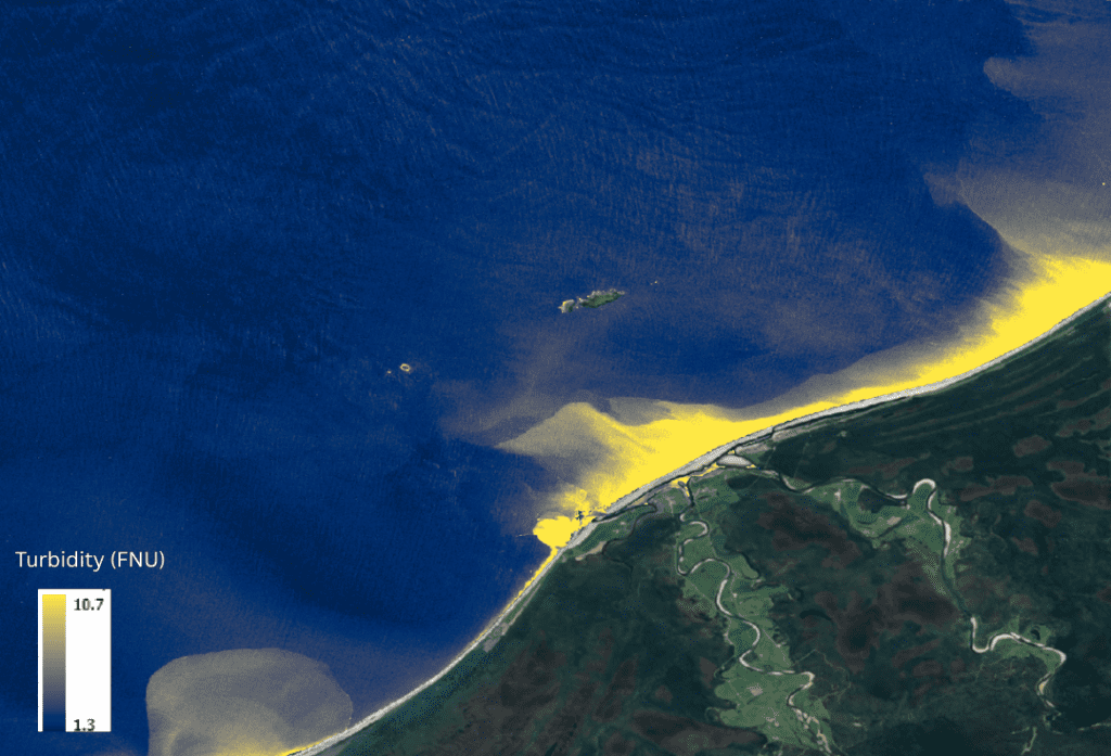
Processed multispectral satellite image from February 2023 showing Turbidity (FNU)

Space-Based Monitoring: A Strategic Advantage

Using high and moderate resolution multispectral satellite imagery from platforms such as Sentinel-2 and PlanetScope, TCarta offers a robust and cost-effective satellite water quality monitoring service. This service enables both historical and near daily evaluation of water conditions across survey sites.

For planning bathymetric lidar flights, satellite-derived data can:

  • Identify optimal collection windows when water clarity is most favorable.
  • Detect turbidity plumes that may limit LiDAR acquisition.
  • Support adaptive flight planning, adjusting flight plans or survey sites to maximize  success based on physics-based analysis.
  • Contextualize data quality after acquisition.

Core Water Quality Metrics

Key parameters analyzed through satellite-based methods include:

  • Kd490: The diffuse attenuation coefficient at 490nm (blue/green). Quantifies the rate at which blue/green light is absorbed and scattered as it travels through the water column.
  • bb490: The backscattering coefficient at 490nm. Indicates the amount of blue/green light scattered back towards the sensor by particles and other constituents in the water column.
  • bbp533: Particulate backscattering coefficient at 533nm. Indicates the amount of green light scattered back toward the sensor by particles. A good proxy for LiDAR laser penetration.
  • Secchi Depth: An indication of how deep light can penetrate into the water column using a simulated Secchi disk.
  • SPM: An estimate of the amount of suspended particulate matter in the water column.
  • Turbidity: The amount of scattered light proportional to the concentration of particles in the water. Sensitive to particle size, shape, composition, density, and color.
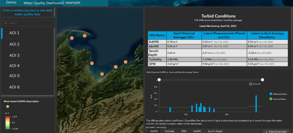
Example of customized Water Quality Dashboard

By combining daily PlanetScope observations with historical Sentinel-2 data, daily monitoring data can be evaluated against historical trends for more accurate anomaly detection. This customizable multi-temporal approach helps surveyors understand both seasonal patterns and real-time shifts in water clarity, supporting strategic mission execution.

Broader Applications: From Planning to Environmental Monitoring

In addition to supporting LiDAR surveys, TCarta’s water quality monitoring is also used across multiple sectors. One key application is the detection and tracking of harmful algal blooms (HABs), which pose risks to ecosystems, public health, and fisheries. Industries such as aquaculture, coastal engineering, and marine construction also benefit from reliable, up-to-date water quality information.

Deliverables

Clients receive access to a customized and dynamic web dashboard along with downloadable reports, graphs, and time series charts. These tools allow users to:

  • Monitor trends over time.
  • Compare current water conditions with historical baselines.
  • Make informed decisions during and after survey operations.
  • Report on water conditions as they relate to collection success.
  • Identify if reflights to infill data gaps will be successful.

Case Study: Florida Coastal Mapping:

Mapping Florida Waters

A Smarter Approach to Survey Success

Space-based water quality monitoring transforms how bathymetric LiDAR missions are planned and executed. By giving surveyors “eyes in the sky,” it enhances operational efficiency, data quality, and overall mission outcomes.

As a leader in satellite-derived marine data solutions, TCarta offers satellite-based Water Quality Monitoring as a key service for LiDAR survey planning and operational support. This forward-looking approach continues to revolutionize the way we collect, analyze, and act on hydrospatial information.


Please contact us through the form below to scope your project or discuss capabilities

Click or drag a file to this area to upload.

What is one plus four (write the number)?

Loading

Connecting Remote Communities: Providing Up-to-Date Data with Satellite-Delivered Bathymetry

TCarta Marine · March 3, 2025 ·

By: David Bautista

Coastal zones have always been an attractive extent for human settlements, providing plenty of natural resources and economic advantages. This interface between land and sea provides multiple benefits, including commerce, trade and transportation, marine resources, and tourism. 

Unfortunately, settlements in far-away and isolated regions face diverse environmental and social challenges. Limited access to health, supplies, and education services; demographic changes affecting the available labor force such as out-migration; higher costs of living; high reliance on natural resources for sustenance; and extreme weather conditions are some examples. 

The effects of global warming also have a major impact on those communities, particularly in the Arctic and Subarctic regions. Remote coastal communities are more vulnerable to environmental and socio-economic impacts of climate change, including coastal flooding, shoreline erosion, saltwater intrusion, habitat loss, and threats to economic activities (fishing, harvesting, and tourism).

There is a greater need for accurate and up-to-date information, especially to understand the morpho-hydrodynamic behavior of coastal areas (seasonal changes in erosion, and transport of sediment and deposition). Monitoring these very dynamic natural systems is thus of great importance for supporting remote communities as well as the conservation of natural resources.

For this reason, governments step in to support adaptability and resilience, and adequate levels of connectivity. Bathymetry with high spatiotemporal resolution is the primary and essential input for understanding the dynamics of coastal systems. However, traditional survey methods, such as multibeam echosounder (MBES) ship-borne, Light Detection and Ranging (LiDAR) airborne, and ground-based are not the most suitable techniques for addressing these concerns.

Traditional survey methods (MBES and LiDAR) provide very high resolution with fine vertical accuracy. However, these techniques face economic and logistic constraints, as well as challenges to map large areas relatively quickly. Thus, Spaceborne Remote Sensing techniques represent an efficient and cost-effective method for mapping remote and hazardous environments. 

Satellite Derived Bathymetry (SDB) can return seafloor depths using spaceborne sensors, such as Sentinel-2, LandSat, Pléiades, WorldView, GeoEye, Planet, and Capella SAR. SDB provides low-cost and un-intrusive solutions with the ability to map changes over time in large remote areas. As a result, SDB is considered to be an overly appropriate alternative to provide data acquisition in remote communities. SDB can be a cost-effective and efficient way to fill in data gaps, support safe navigation (updating nautical charts data in the coastal waters), and enhance the understanding of the marine environment.

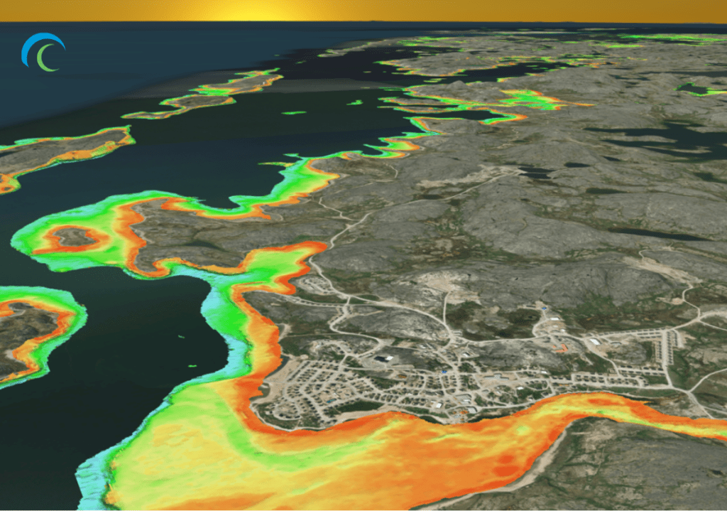
10m SDB over Inukjuak, QC, Canada

Through a Canadian Hydrographic Service (CHS) contract and with IIC Technologies as Prime Contractor, TCarta facilitated 10m SDB datasets in the waters around Inukjuak and Ulukhaktok, Canada.

Inukjuak is a remote, traditional Inuit community located in Nunavik, Northern Quebec, Canada, with more than 1,500 people bordering the Hudson Bay. The region is influenced by the Southern Arctic conditions and characterized by a cold dry climate with a continuous permafrost. The mean annual temperature is -6ºC; cold conditions persist over long periods during winter (mid-November to March), where temperatures less than -15ºC persist and thaws are infrequent. Hudson Bay usually freezes by the end of December, near the coastline, and ice usually melts in late June or early July.

Ulukhaktok, another Inuit community with fewer than 500 inhabitants, is located on the west coast of Victoria Island, the second largest island in the Canadian Arctic archipelago and the ninth-largest island on Earth. There are prominent cliffs that line the shore, lowlands, and numerous ponds, lakes, and rivers. Seasons are weather and ice dependent. Summer is characterized by open water from early July to September; during fall (October through mid-November) sea ice freeze-up, and winter is characterized by frozen sea conditions. Speed and direction of the wind influence sea ice freeze-up and breakup.

Both communities are only reachable by plane, helicopter or boat. Its economy depends on hunting,  fishing, trapping, and gathering; hunters and fishers catch wildlife and fish from the waters and islands of Hudson Bay in Inukjuak and the coastal waters of Prince Albert Sound and Minto Inlet in Ulukhaktok.

Understanding the importance and relevance of surveying all optically shallow water in these regions; TCarta deployed a hydrospatial survey with cutting-edge remote sensing techniques. The negative effects of local water column and atmospheric conditions were controlled using multi-temporal image composites. Sentinel-2 Level-1C imagery was selected, and a minimum of 100 singular atmospherically corrected images were statistically combined. The combination of multi-temporal images allowed to obtain the “best” pixels for SDB derivation.

TCarta successfully delivered 982.8 km² of SDB coverage, 855.2 km² in Inukjuak and 127.6 km² in Ulukhaktok. The efforts for this hydrospatial survey will benefit both communities with up-to-date data. Lastly, TCarta is pleased to announce how the produced SDB accomplished the overlaying goals of filling the gaps in coastal bathymetry, enhancing understanding of the marine environment (especially, the fact that its economy certainly depends on hunting and fishing, and filling data gaps supports such activities), and supporting safe navigation in the Canadian Arctic. This type of project exemplifies the necessity of state-of-the-art SDB technology in remote locations, and the capabilities of hydrospatial solutions.

Subscribe to our newsletter


Loading

TCarta Marine LLC

1015 Federal Boulevard
Denver, CO 80204, USA

+1 (303) 284-6144

TCarta Caribe LLC

26 Haining Road
New Kingston, Jamaica

+1 (876) 817-8567

TCarta Canada Services Ltd.

1771 Robson Street - 1508
Vancouver, BC, V6G 3B7 CA

  • What We Do
  • Legal
  • Contact
  • LinkedIn
  • Instagram
  • Facebook
  • Twitter