Canadian summer internship programme trains hydrographers of the future
Three marine organizations teamed up in the summer of 2023 to prepare
Canadian ocean mapping students to become ‘hydrographers of the future’.
The first-of-its-kind internship programme focused on equipping the students with the technical skills and knowledge that are increasingly required in the hydrography profession but are not yet taught in many college programmes because they are so new and evolving at such a rapid pace.
“The hydrographer of the future must still understand traditional marine science and ocean survey practices, but in addition will need training in automated marine and airborne sensor systems, satellite-based Earth observation platforms and artificial intelligence applications.” said Kyle Goodrich, president of TCarta Marine, the Colorado firm that spearheaded the programme.
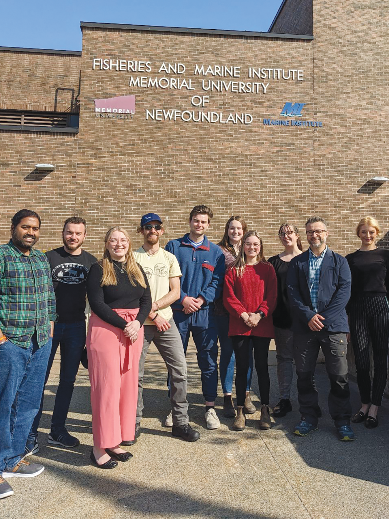
Six undergraduate and two graduate students participated in the summer-long paid internship co-sponsored by, and held at, the Marine Institute (MI) of Memorial University in St. John’s, Newfoundland. All eight students were enrolled in the MI Ocean Mapping programme. Mobilization of the programme was shared among TCarta, Memorial University and The Nippon Foundation-GEBCO Seabed 2030 Project, which seeks to inspire the complete mapping of the seafloor by 2030.
“Field work will remain a key part of hydrography, but hydrographers will also have to be data scientists, ” said Paul Elliott, academic director and instructor in the MI Master of Applied Ocean Technology programme. “There is so much data being collected from many different technologies, and hydrographers must know what to do with it.”
Another objective of the internship was to make hydrography more attractive as an academic pursuit and profession at a time when the need for trained ocean mappers is expanding. This demand is being driven by increased offshore hydrocarbon exploration, renewable energy siting and coastal development, all of which require detailed seafloor mapping.
The reactions from the students on completion of the hands-on course were overwhelmingly positive. Each had a slightly different experience, but the most common takeaways were excitement about acquiring additional employable skills, surprise at discovering new facets of the hydrography profession, and enthusiasm in playing a part in the Seabed 2030 initiative. “I’ve definitely learned skills that I otherwise wouldn’t have learned in the classroom,” said Kaitlin Power, a third-year MI Ocean Mapping student.
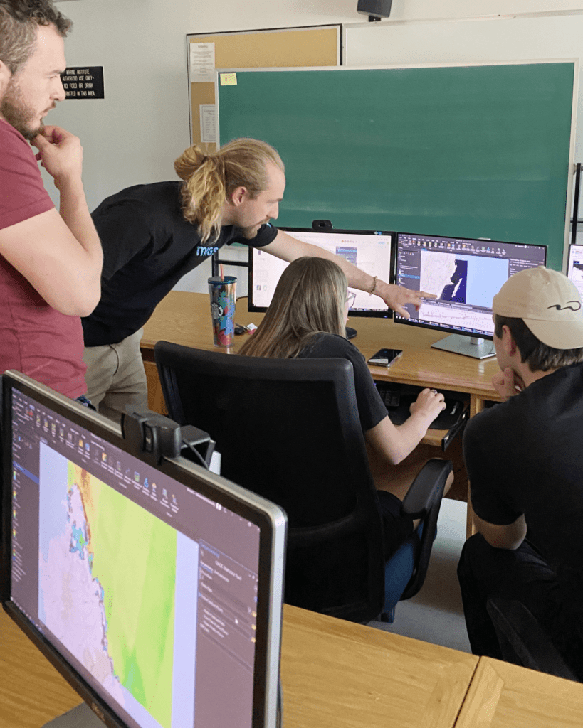
The internship delivered these experiences in a real-world work environment. Spending eight-hour days in the MI computer laboratory, the students received traditional instruction from TCarta personnel followed by intensive collaborative work on seafloor mapping projects. Some datasets were delivered to TCarta customers as commercial products, while others were provided to Seabed 2030 for inclusion in the global GEBCO grid.
Instruction in integrated technologies
The 2023 curriculum focused on training the students in the application of satellite derived bathymetry (SDB), a technique that derives seafloor depth in shallow water, usually in coastal zones, through analysis of multispectral satellite imagery. SDB served as an ideal instructional tool because it integrates multiple state-of-the-art technologies, many new to hydrography. “SDB fills the gap in shallow-water data collection where it’s too risky to operate traditional bathymetric survey technology,” said Elliott.
Dating from the days of the U.S. Landsat mission in the 1970s, SDB is a less expensive and safer method of measuring bathymetry in the near-shore environment than traditional shipborne, or even airborne, techniques. SDB achieved mainstream status in 2020 when the U.S. National Oceanic and Atmospheric Administration (NOAA) and the UK Hydrographic Office adopted the technology as an official hydrographic survey method. Numerous international ocean mapping agencies followed. In 2021, Seabed 2030 specifically requested SDB data as a cost-effective technique for near-shore mapping.
Over the past decades, the quality of SDB mapping increased as spatial resolution of satellites improved, although the core processing algorithms remained the same. It was widely agreed that the technology needed an overhaul. TCarta applied for funding from NOAA and the National Science Foundation to upgrade the entire SDB workflow with state-of-the-art processing capabilities and expand its applicability to deeper, murkier waters, especially in Arctic regions.
Through the SDB training, the interns were introduced to dozens of new technologies and skills, some that are outside the typical course curricula for most hydrography students. Although technologies such as satellite imaging and artificial intelligence may be unique to the SDB workflow for now, TCarta is confident that they will soon be integrated into other ocean mapping methodologies.
Key capabilities
Students were taught many key capabilities during the summer. For instance, they were introduced to the variety of satellite imagery available for SDB and studied the strengths of each for certain project types. For example, no-cost coarse-resolution ESA Sentinel-2 A/B satellite data was used for broad geographic coverage, while high resolution Maxar WorldView imagery was processed for targeted, site specific applications.
TCarta also instructed the interns on how to use a pre-processing tool to prepare in situ data from sonar or Lidar as calibration datasets for processing the satellite images. Furthermore, they learned how to apply an enhanced version of a traditional band ratio algorithm along with a newly devised machine learning random forest algorithm in iterative processes to derive water depth measurements from individual image pixels.
Another capability taught was how to harness the power of cloud computing to apply the SDB algorithms to stacks of multi-temporal Sentinel images acquired for the same location at dozens of different times. The interns also used an artificial intelligence-based QA/OC tool to apply Lidar data from the NASA ICESat-2 satellite to evaluate and validate the SDB outputs. FMABE 3D point cloud software developed by the U.S. government was also employed to edit hydrograpnic datasets to produce final deliverables.
“Having these skills puts us at an advantage over other students who will be looking for work in the future,” said Maggie Lewis, also a third-year ocean mapping student.
Creating real world products
For Will Edwards, an MI Ocean Mapping student, part of the internship’s attraction was working on SDB products that would be deliverables for real end users, especially the Seabed 2030 endeavour, which is considered the highest profile seafloor mapping project in the world right now. “I am really happy to get the opportunity to provide data to Seabed 2030…I had been waiting a few years to do that,” said Edwards. “I’m glad the data [we produced] was accurate enough to be used.”
“The SDB datasets provided by the students of the summer internship are instrumental in supporting the global effort underway to deliver a complete map of the ocean floor by 2030,” said Seabed 2030 Director Jamie McMichael-Phillips. “We are delighted to support this collaborative internship co-sponsored with our partners Memorial University and TCarta, enabling students to acquire cutting edge hydrospatial skill sets and equipping them for their future careers as modern hydrographers.”
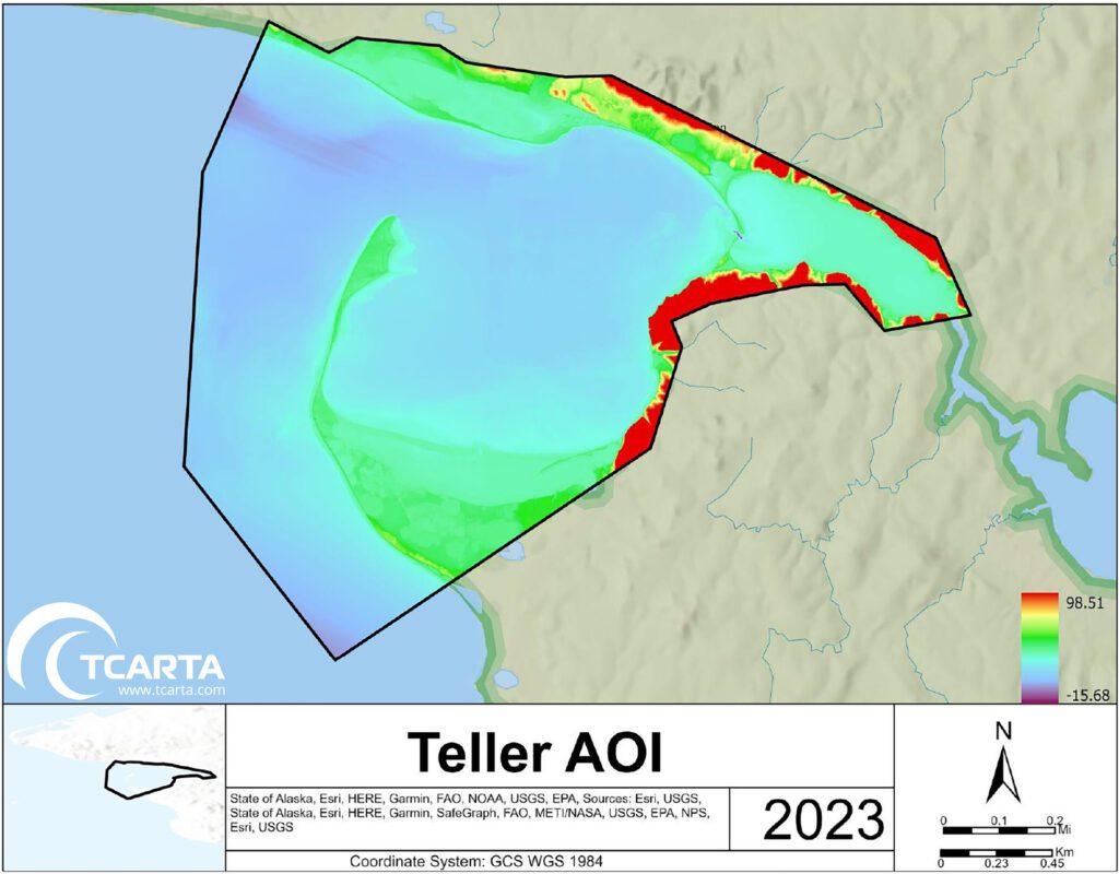
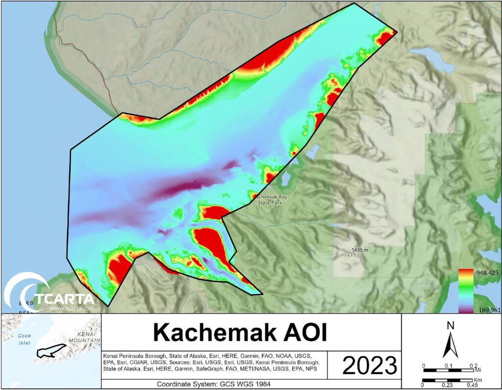
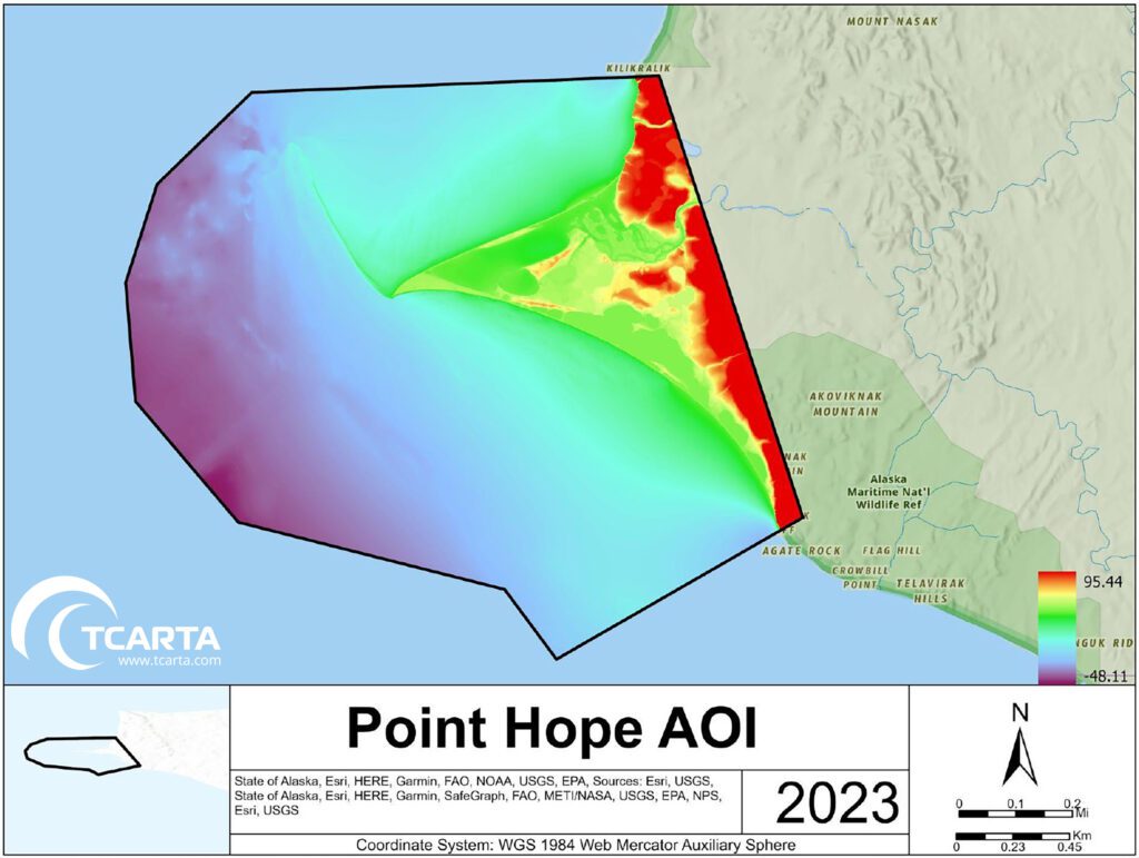
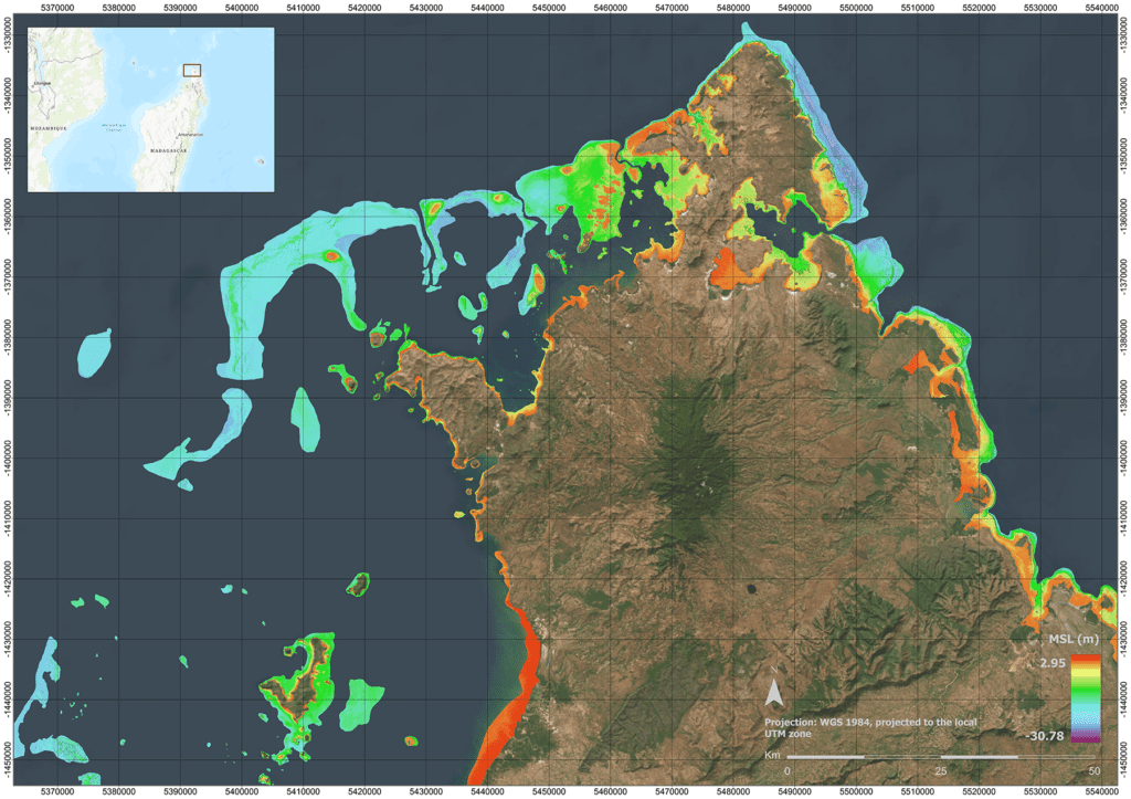
In total, the interns created more than 21,125 square kilometres of SD coastal products during the 12-week session. Key datasets included:
• the entire Newfoundland coastline and three Arctic regions for MI research;
• Timor Island in Asia and New Hanover Island in Papa New Guinea for Seabed 2030; and
• the entire Madagascar coastline off the coast of Africa for a TCarta client.
“The students took what they learned in the classroom and applied it to real projects with actual data and deadlines. They learned what they have to do to get a project completed,” said Elliott. “They therefore know what will be expected from them when they join the workforce.”
MI’s success at educating hydrography students has put it at the top of ocean mapping programmes worldwide. The Master’s programme has been recognized by the International Hydrographic Organization as one of the few to receive the
S-5A standard of competence.
Success and what’s next
The internship programme succeeded on many levels. Among the most important was resetting the students’ expectations of what a future career in hydrography might look like. MI hydrography instructor, Olga Telecka, explained: “Hydrography has traditionally been a profession in which most data collection work was conducted on a ship. For many, the prospect of spending weeks or months on a boat away from home eliminated hydrography as a professional choice. But now that so much data is being collected remotely and with data analysis being performed in onshore labs, the profession offers opportunities for both maritime enthusiasts and land lovers.”
“What [the students] learned in the internship is that hydrographers don’t necessarily need to go on a vessel to have a career in this industry, which for some is very important,” continued Telecka. “This programme opens the horizon.”
Telecka added that for MI, the course reinforced the value of academic-industry partnership. Working professionals can expose students to cutting edge technologies already being used in the commercial world before they find their way into textbooks. Based on the positive experience with TCarta, MI is considering other technologies to feature in future internships.
TCarta is working closely with MI to refine the SDB programme and sponsor it again next summer. “The programme showed us that a non-distracted group of new-to-SDB people could take a new technology in a short time period and produce solid, professional work – as students,” said TCarta’s Goodrich. “The students performed better than we anticipated, impressing us with their eagerness and interest in improving the new processes they were learning.”
The internship organizers hope that the internship format will provide a template for other academic programmes and private sector companies to introduce hydrography students to the latest technologies, helping them to understand the full breadth of the profession and making it more appealing in the process. While the internship succeeded in preparing students to become hydrographers of the future, Goodrich noted, the hydrography industry still has much work to do in attracting more students to the discipline. He challenges private sector colleagues and academics to do more in promoting hydrography and ocean mapping to young people long before they reach university.
For universities, the key is collaboration. MI’s Elliott recommended that academic institutions look for partners in the commercial world to partner with, as his did with TCarta to help make the transition to the working world easier for the students.
About the author: Kevin Corbley is a business development consultant with more than 30 years of experience in the geospatial profession. He is based in Colorado, USA.