• Skip to primary navigation
  • Skip to main content
TCarta Satellite-Based Hydrospatial Tech

TCarta Satellite-Based Hydrospatial Tech

We are your contact for Marine Remote Sensing and Hydrospatial data services.

  • Who We Are
    • About
    • Partnerships & Affiliations
  • What We Do
    • What is Hydrospatial?
    • What Do We Measure?
    • How to Work with TCarta
  • Products & Services
    • Products
      • Global Bathymetry GIS
      • Satellite-Derived Bathymetry
      • Seafloor Classification
      • Newsletter Archive
      • Marine Basemaps
    • Services
      • Blue Carbon Mapping
      • Synthetic Aperture Radar (SAR)
      • Satellite-Derived Water Quality
      • Trident Tools Satellite-Derived Bathymetry Software
    • Custom Solutions
  • Case Studies
    • Space-based Hydrospatial Solutions for Engineering Projects in the Littoral Zone
    • Technology Demonstration Project: Large-Scale Satellite Derived Bathymetry Mapping
    • Hydrographic Office Technology Integration
    • Updating Information on Nautical Charts in Baffin Island, Canada
  • News & Press
    • Newsroom
    • Blogs
  • Product Viewer
  • Contact
  • Show Search
Hide Search

Amy Anfinrud

Mapping Florida Waters

Amy Anfinrud · December 31, 2023 ·

Dewberry works with Florida Department of Environmental Protection to map the Gulf Coast of Florida sea floor.

Read in LIDAR Magazine

Coastal Zone Mapping and Imaging Lidar (CZMIL) SuperNova nearshore topobathymetric lidar along the Gulf Coast of Florida.

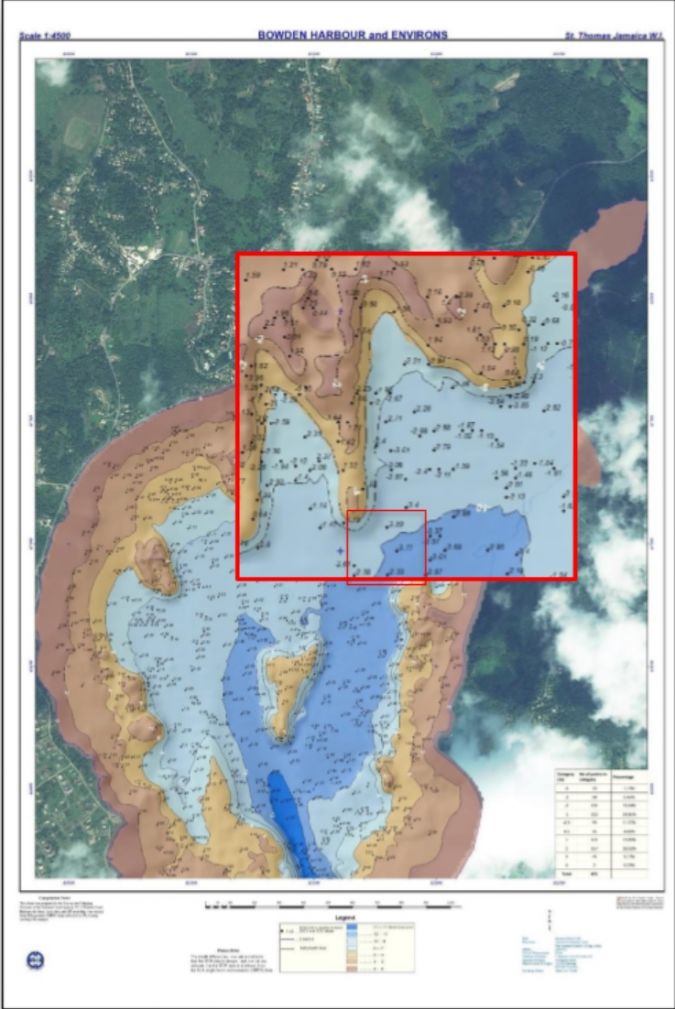
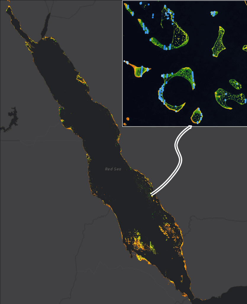
Florida boasts the longest coastline of any state in the contiguous U.S., with over 8400 linear miles (NOAA method)1. Florida also has the largest submerged shallow shelf on the Gulf of Mexico/Atlantic Ocean and the only coral reef system (Figure 1) in the contiguous U.S. (Florida Department of Environmental Protection’s Office of Resilience and Coastal Protection).

Figure 1: The six regions identified by FCMaP and subsequently adopted by FSMI. Coral reef area shown in pink.

As about two-thirds of Florida forms a peninsula between the Gulf of Mexico and the Atlantic Ocean, the state is especially prone to tropical storms and cyclones/hurricanes. Since 1851, 121 named and unnamed hurricanes have hit Florida, more than any other state2, and since 2017, four storms have made landfall along the Gulf Coast, including hurricanes Irma (2017), Michael (2018), Ian (2022), and Idalia (2023). Hurricane Ian was the third most costly hurricane to hit the U.S., on record with a price tag of more than $113 billion. Losses resulting from Hurricane Idalia, still being tallied, are also considerable. With increasing ocean temperatures fueling tropical storms, we can expect hurricane intensity and frequency to increase into the future.

In response to the compounding effects of sea-level rise, coastal subsidence, and growing population pressure on the coastline, Florida has been placing increased importance on coastal resilience and sustainability. In 2019, the Florida Department of Environmental Protection (FDEP) created the Office of Resilience and Coastal Protection (ORCP)3 to guide its efforts. FDEP/ORCP has a multi-faceted approach to resilience, including coral reef protection, preservation of coastal and aquatic management areas, beach and inlet management, and the implementation of ecosystem restoration projects to prepare Florida’s coastal communities and state-managed lands for the effects of sea level rise, coastal flooding, erosion, and storms.

In 2022, the Florida Legislature allocated $100 million in general revenue funds to FDEP/ORCP for the Florida Seafloor Mapping Initiative (FSMI), to capture statewide topobathymetric lidar to the 20-meter isobath and acoustic/sonar soundings from the 20-meter isobath to the 200-meter isobath. FDEP/ORCP and the Florida Geographic Information Office (FGIO) constructed timelines and published anticipated schedules on respective program webpages. FGIO produced a dashboard4 to share the collection regions, progress updates, and data processing status.

Figure 2: Dewberry/NOAA topobathymetric and shoreline mapping projects in Florida along the Gulf Coast: the panhandle of Florida through the Anclote River (Hurricane Michael/Big Bend); Tampa Bay; the Manatee River outlet through Naples (Hurricane Ian/Charlotte Harbor); and, along the Atlantic Coast, the Indian River Lagoon. Areas in purple are FSMI regions assigned to Dewberry for CZMIL SuperNova mapping.

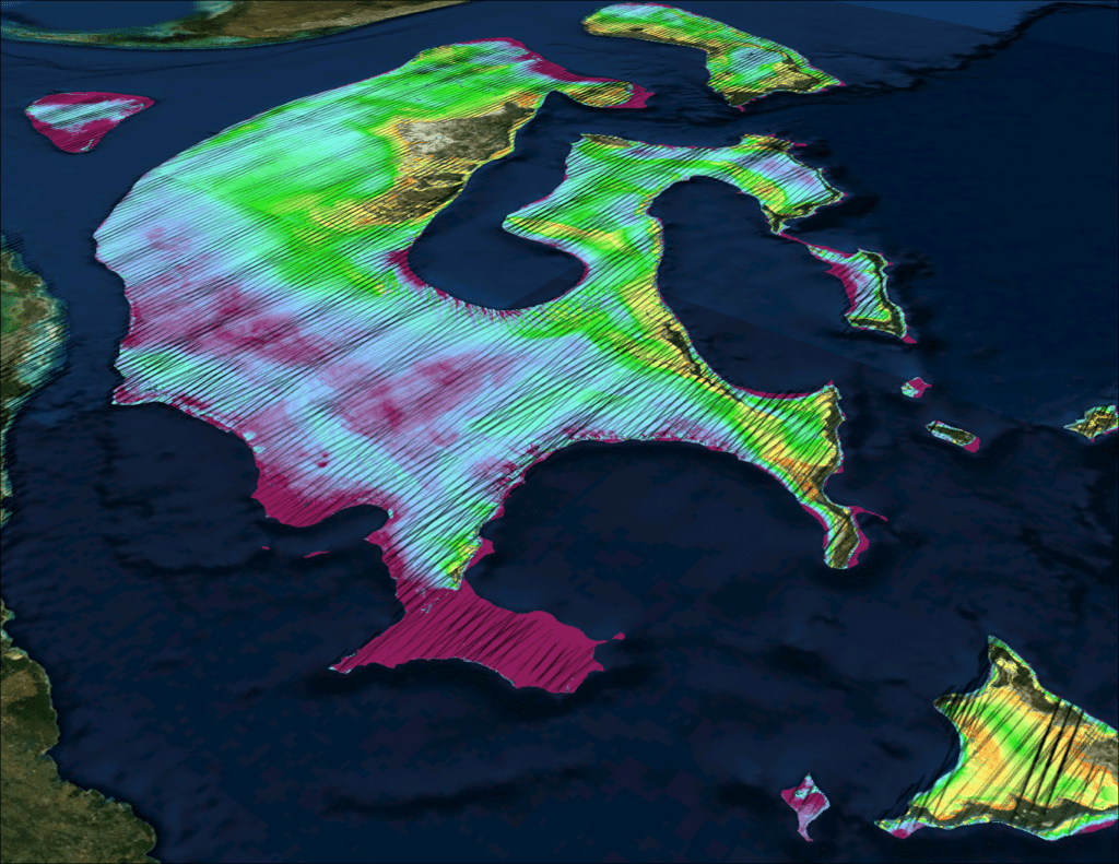
For many of the reasons indicated above, the Office of Coastal Management (OCM) of the National Oceanic and Atmospheric Administration’s (NOAA) has been updating navigation charts and coastal surveys along Florida’s coastline. Since 2018, Dewberry has been updating large segments of the coastline and mapping the bathymetry using topobathymetric lidar (Figure 2). Some of these efforts preceded FSMI; while some areas of interest coincide with FSMI, and some are being collected simultaneously with and complement the FSMI project. This article discusses the first phase of FSMI, specifically updates to the bathymetry and shoreline mapping along the Gulf Coast of Florida.

The FSMI project area

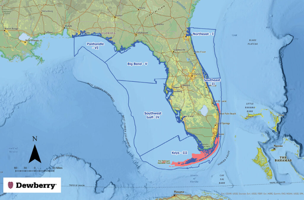
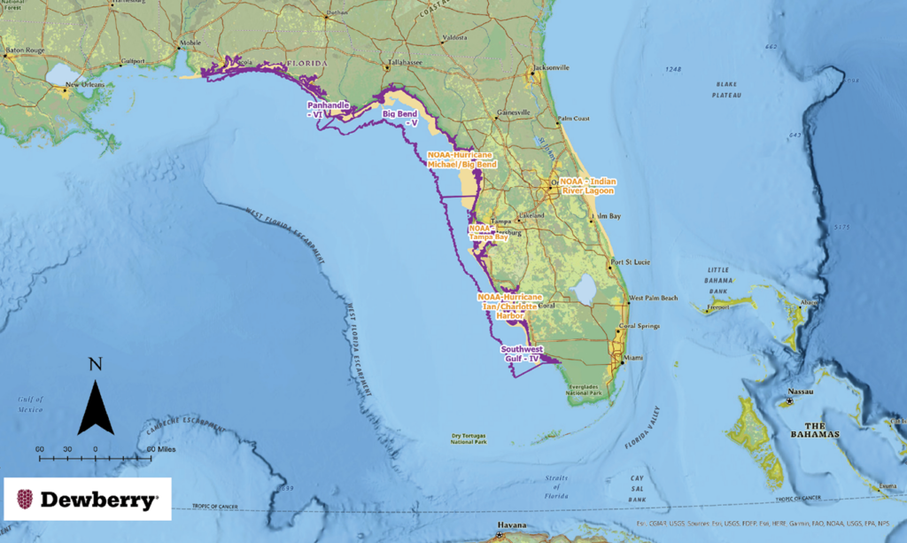
In 2017, the Florida Coastal Mapping Program (FCMaP)5 designated six regions of Florida as the basis for studying the quality of available bathymetric data. FDEP/ORCP adopted those six regions (Figure 1) as the basis for awarding contracts to topobathymetric lidar and multi-beam sonar providers. Each region was identified with a name and a region number, starting in northeastern Florida and proceeding clockwise through the Florida panhandle:

  • Northeast-Region I
  • Southeast-Region II
  • Keys-Region III
  • Southwest Gulf-Region IV
  • Big Bend-Region V
  • Panhandle-Region VI

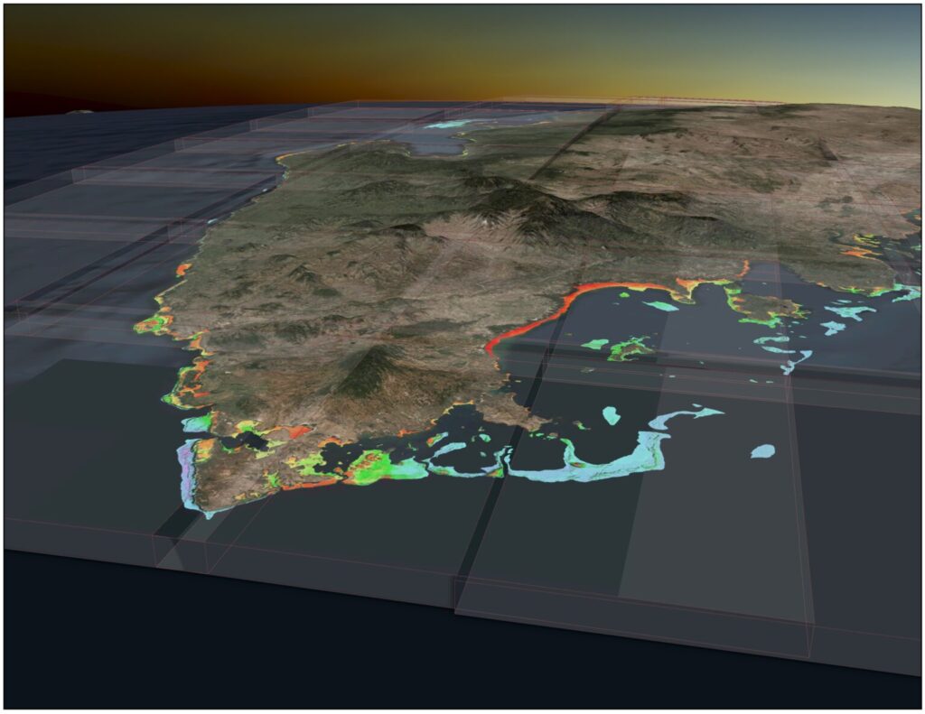
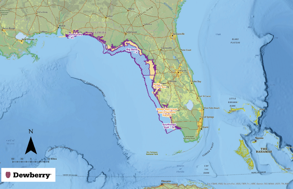
The project is separated into two phases. Phase one focuses on using topobathymetric lidar to collect bathymetry to the 20-meter isobath. This topobathymetric lidar phase spans approximately 58,000 km2 as illustrated in Figure 2. Phase two will focus on collecting acoustic, multi-beam sonar data for water depths between 20 meters and 200 meters.

Dewberry’s role

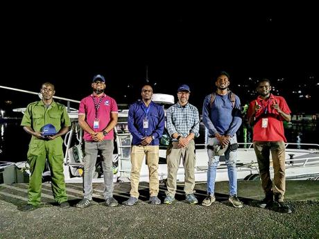
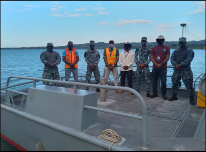
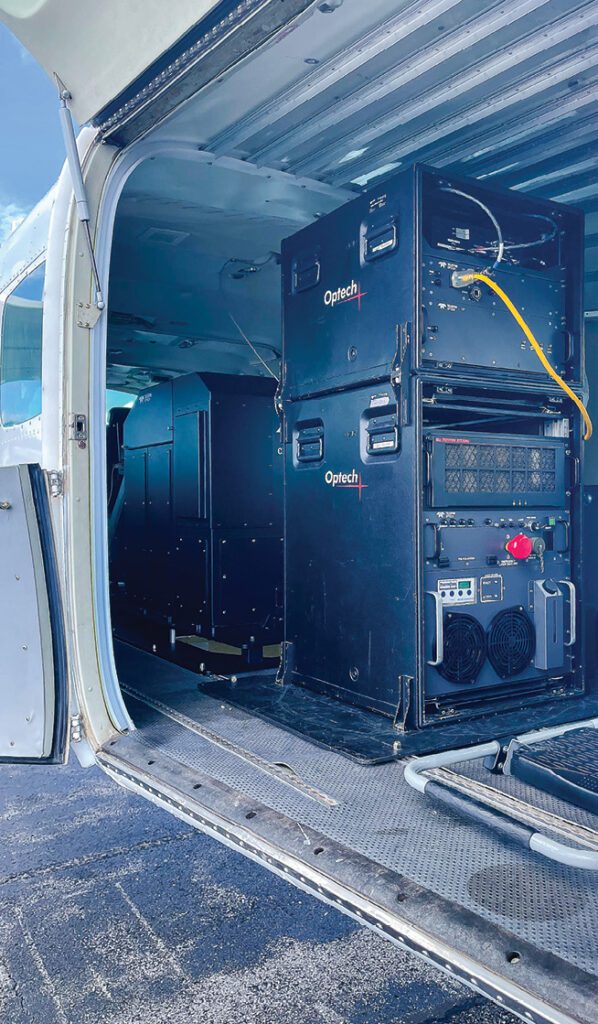
Dewberry was awarded approximately 25,000 km2 of the project for topobathymetric lidar mapping, including the entire Gulf Coast of Florida, from Pensacola in the western panhandle south through Naples (Figure 3). This includes Southwest Gulf–Region IV, Big Bend–Region V, and Panhandle–Region VI. Dewberry is deploying three CZMIL SuperNova topobathymetric lidar sensors for data collection, which were chosen based on their ability to measure up to 3.5 secchi disk depth through the water and to the 20-meter isobath. The sensors are mounted in Cessna Caravan airframes operating from bases throughout the project area (Figure 4).

Figure 3: FSMI regions for topobathymetric lidar mapping; water depths to the 20-meter isobath in purple. Dewberry was tasked by NOAA to collect near-shore lidar bathymetry in the Big Bend-Region V area (see tan areas in Figure 2) for the NOAA/Hurricane Michael Relief Program. The FSMI area of interest was refined to include only the hatched area.
Figure 4: Dewberry’s CZMIL SuperNova sensor mounted in a Cessna Caravan. This sensor is housed at the Peter O. Knight Airport in Tampa, Florida.

Current progress

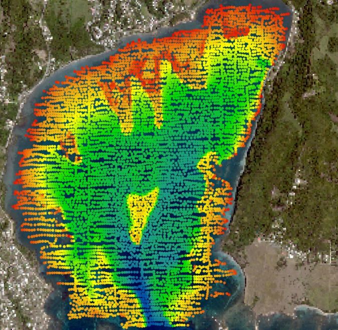
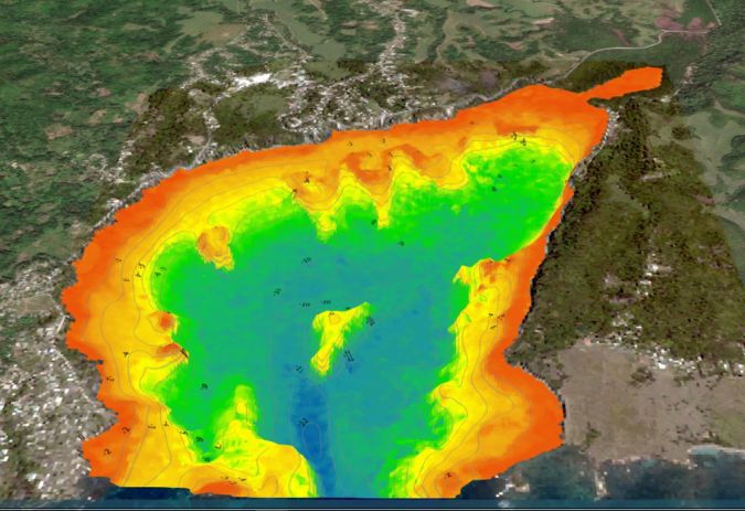
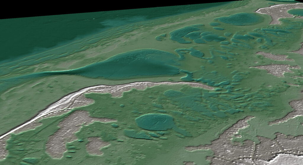
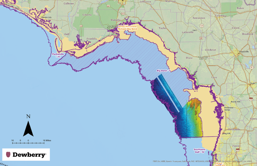
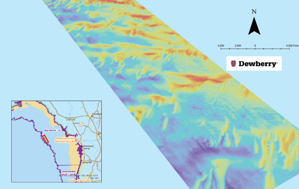
Dewberry started collecting lidar bathymetry in Big Bend–Region V in July 2023 and continued through the end of August 2023, when Hurricane Idalia made landfall in the Big Bend region near Steinhatchee. By late August, Dewberry had collected approximately 31% (~3500 km2) of the area of interest in Big Bend-Region V (Figure 5), and almost 20% (~600 km2) in Panhandle-Region VI (Figure 6).

Figure 5: Quicklook showing CZMIL SuperNova topobathymetric lidar coverage collected prior to Hurricane Idalia, August 2023, in the Big Bend-Region V of the FSMI. Data coverage extends to the 20-meter isobath on the west, and approximately 30% of the Region V area. The tan area was collected for the NOAA/Hurricane Michael Relief Program.
Figure 6: Detailed digital elevation model derived from CZMIL SuperNova returns near the 20-meter isobath in the Big Bend-Region V.

Preliminary results

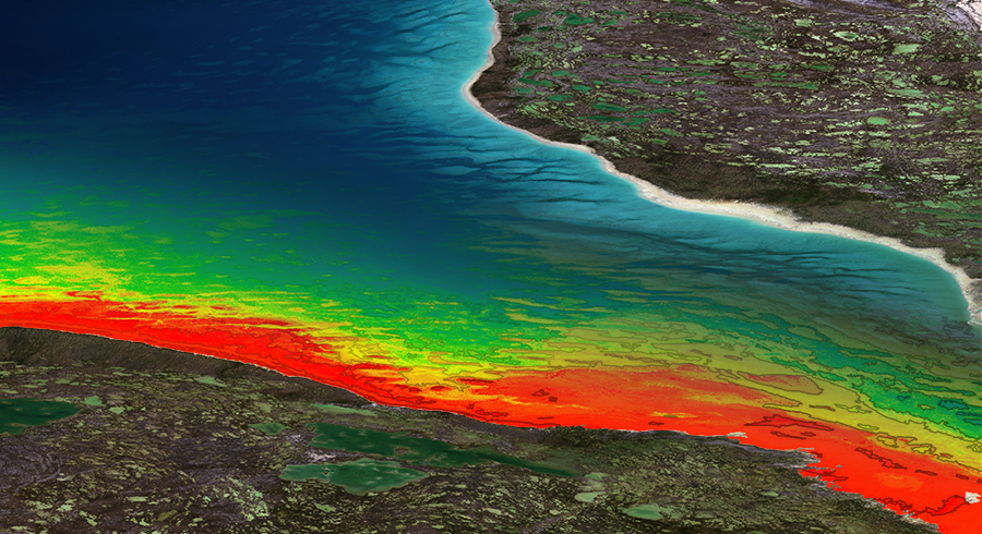
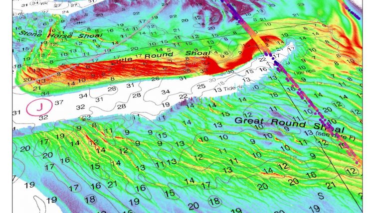
Dewberry is currently processing and calibrating the initial CZMIL SuperNova data from August 2023 using the Teledyne CARIS software. Dewberry has also developed a custom process to create “Quicklook” products that allows visualization of the topobathymetric lidar without expending considerable processing time and expense. Figure 5 shows the extent of the CZMIL SuperNova data collected prior to Hurricane Idalia for the southern portion of Big Bend-Region V. The preliminary results of the topobathymetric data reveal features and bathymetry extending out to the 20-meter isobath and completely within the near-shore area of interest (Figures 5 and 7).

Figure 7: Quicklook showing CZMIL SuperNova topobathymetric lidar coverage collected prior to Hurricane Idalia, August 2023, in the Panhandle-Region VI. Data coverage extends to the 20-meter isobath on the south, and approximately 18% of the Region VI area. The tan area was collected for the NOAA/Hurricane Michael Relief Program.

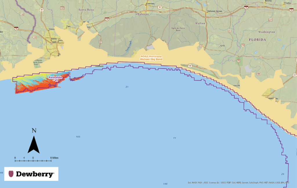
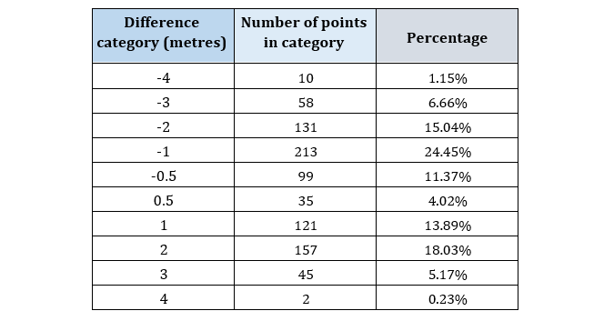
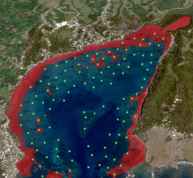
Further investigation of the Quicklook data in the Big Bend area revealed that the CZMIL SuperNova sensor was recording highly detailed bathymetric returns near the 20-meter isobath (Figure 6), which led the FDEP/ORCP to modify the task orders to include lidar bathymetry past the 20- meter isobath.

Innovative planning methodology

Planning aerial acquisition missions, and particularly topobathymetric missions in Florida, presents unique challenges. With the flat inland and coastal topography, even low-yield, inland rain events can result in large amounts of particulate runoff into the Gulf of Mexico. Combining the runoff with tannic components, such as those in the Suwannee River system in Big Bend, can result in poor water quality and unfavorable conditions for lidar bathymetry.

Figure 8: A daily water condition report for 16 October 2023 for 22 locations distributed in the Big Bend and Panhandle Regions, showing three (Kd492, Bb592, and Secchi Depth) metrics. Gray sample locations were clouded over on the date indicated and no data was generated; pink were below normal expected values; yellow, within normal expected values; green, better than normal expected values.

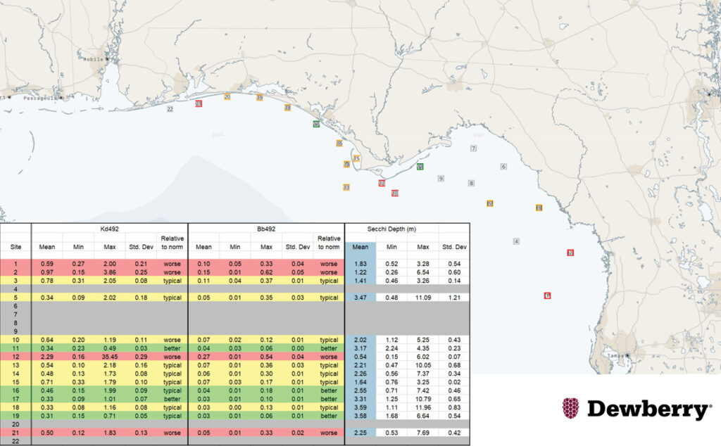
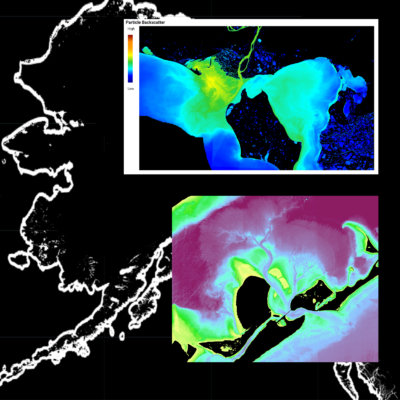
To help avoid collecting lidar during sub-optimum water clarity conditions, Dewberry has partnered with TCarta to provide satellite-derived bathymetry (SDB) for 22 selected sites dispersed throughout the regions. TCarta delivers the water clarity estimates daily based on several metrics, including the diffusion coefficient (Kd492), the backscatter coefficient (Bb492), and secchi disk depth (Figure 8) to help evaluate the water clarity and interpret current water conditions relative to historic norms. This methodology has helped Dewberry minimize non-productive flights, therefore increasing efficiency and decreasing environmental carbon dioxide loading.

Reference

Florida Department of Environmental Protection, 2023. Florida’s Coral Reefs, https://floridadep.gov/rcp/rcp/content/floridas-coral-reefs (accessed 20 October 2023).


1 coast.noaa.gov/czm/mystate/

2 cnn.com/2017/09/11/us/hurricanes-landfall-by-state-trnd/index.html

3 floridadep.gov/orcp

4 floridagio.gov/pages/FSMI

5 fcmap-myfwc.hub.arcgis.com

6 Maune, D.F. and A. Nayegandhi (eds.), 2018. Digital Elevation Model Technologies and Applications: The DEM Users Manual, 3rd Edition, ASPRS, Bethesda, Maryland, 652 pp.

back to newsroom

Growth & Jobs | NLA uses hydrography to harness potential of blue economy

Amy Anfinrud · December 19, 2023 ·

The National Land Agency (NLA) has been using hydrography to harness the potential of the blue economy, while fulfilling its mandate of mapping the landscape of Jamaica’s territorial waters.

Read in The Gleaner

From left: Member of the Jamaica Defence Force Coast Guard, L.S. Cox; senior hydrographic surveyor at the National Land Agency (NLA), Diego Billings; NLA’s assistant hydrographic surveyor, Brian Scott; president of the TCarta Marine LLC, Kyle Goodrich; assistant hydrographic surveyor, NLA, Matthew-Dane Henry; and field assistant, NLA, Orean Hinds, pause for a photo after a technical exchange activity where the NLA team trained the TCarta president on how to use a multi-beam echo sounder to determine the water depth of the East and West harbours in Port Antonio, Portland.

The blue economy is the sustainable use of ocean resources for economic growth and improved livelihoods and jobs, while preserving the health of the ocean ecosystem.

In a recent interview with JIS News, senior hydrographic surveyor at the NLA, Diego Billings, pointed out that having an “improved understanding of the sea floor, through hydrography, can be used to harness the full potential of the blue economy by seizing opportunities to boost economic growth, improve livelihoods and intensify trade activities, all while preserving the sea’s ecosystem”.

He added that, through its Topographic Hydrographic Survey Unit, the NLA has continued, and continues, to “honour its fulfilment to stakeholders through the collection, maintenance and distribution of accurate data obtained from regular surveys of Jamaica’s ports and harbours”.

This is done through routine surveys conducted in different locations throughout the year.

“Since the start of the year, surveys have been conducted at Rosey Hole, Port Royal and the west and east harbours of Port Antonio, and plans are in place for four additional hydrographic surveys to be conducted at the Montego Bay, Negril, Black River and Ocho Rios harbours by the end of 2023,” Billings pointed out.

“The information collected from these surveys is crucial for ensuring smooth and safe navigation for ships and other marine activities,” he informed.

Some of these activities include maritime boundary delimitation, national marine spatial data infrastructure, marine defence and security, coastal zone management and recreational boating, among others.

The senior hydrographer also shared that the quality of the hydrographic survey results has been enhanced with the help of technological advancements over the years.

One such enhancement is the employment of the Satellite Derived Bathymetry (SDB) method in hydrographic surveys.

This approach, said Billings, “enables us to produce bathymetric maps of extensive regions, which allows for more effective and efficient use of time and resources”.

The first accomplishment using this method was achieved through a collaborative case study with TCarta Caribe in 2020 when a hydrographic survey of the Bowden Harbour in St Thomas was completed using the SDB.

Billings also noted: “Drones have been used to map the shorelines of the seas, which has resulted in significant reduction in the overall time it takes to complete surveys.”

Against the background of Jamaica being a council member within the International Hydrographic Organization (IHO), Billings said that “with such responsibility, there is increased motivation to expand the country’s imprint in the arena of ocean mapping”.

Plans are therefore underway for Jamaica to participate in the Nippon-Foundation-GEBCO Seabed 2030 Project.

“This initiative aligns with the United Nations Sustainable Development Goal 14, which is to conserve and sustainably use the oceans, seas and marine resources for sustainable development,” Billings pointed out.

As part of the project, hydrographers from the NLA will be tasked with mapping Jamaica’s Exclusive Economic Zone (EEZ).

The team will consist of two Category-A and one Category-B hydrographic professionals who have received international training and are certified by the International Federation of Surveyors, IHO and the International Cartographic Association.

“It will be a challenging-yet-rewarding endeavour. By 2030, the hydrographic data collected from Jamaica’s EEZ will be combined with other seabed mapping data to create a comprehensive digital map of the world’s ocean floor,” Billings noted.

“We are enthusiastic about the potential of this global endeavour and its impact on the development of Jamaica’s blue economy,” he added.

On June 21, the NLA joined the rest of the world to celebrate World Hydrography Day, under the theme ‘Hydrography – Underpinning the Digital Twin of the Ocean’.

Back to newsroom

Navigating the Depths: Charting and Preserving Coastal Assets

Amy Anfinrud · December 11, 2023 ·

In this blog, we’ll delve into the topic of coastal mapping and preservation. Our focus: why mapping and updating global coastlines matter significantly.

Understanding the Significance

The earth’s coastal regions are dynamic, ever-changing interfaces where land and water coalesce. These zones are teeming with life, offer abundant resources, and provide valuable avenues for trade and transportation. However, as climate change accelerates and sea levels rise, the need for precise coastal mapping becomes increasingly paramount.

Why Coastal Mapping Matters

Coastal mapping is not a challenge confined to a single nation. It’s a global endeavor that requires cooperation and data sharing among nations. Accurate maps of coastlines are indispensable for numerous sectors, such as marine navigation, disaster preparedness, resource management, and environmental conservation. The responsibility to map these vital areas is a shared one, calling for international collaboration.

Who Takes the Lead?

While many organizations around the world engage in coastal mapping and ocean mapping, TCarta is a key player in this arena. We are dedicated to providing nations with the tools and data they need to map and monitor their coastlines effectively.

Global Initiatives such as Seabed 2030 (the Nippon Foundation & GEBCO), Map the Gaps and Crowd Sourced Bathymetry Working Group (IHO) bring various stakeholders, technologies and resources together to map the world’s waters.  These organizations understand the critical nature of Ocean Mapping; as Map the Gaps states on their homepage, “We can’t protect what we don’t understand and we can’t understand what we don’t measure.” TCarta has engaged with Seabed 2030 and Map the Gaps to provide satellite derived national datasets where there is either no pre-existing data or data is long outdated.

The TCarta Approach

TCarta offers a suite of satellite-based services aimed at helping nations better understand, monitor, and manage their coastal zones. The approach involves a synergy of cutting-edge technology, scientific expertise, and global collaboration.

How TCarta Provides Value

1. Bathymetric Surveys: TCarta employs state-of-the-art technology, including multibeam sonar and satellite imaging, to map the ocean floor accurately. This data is crucial for safe navigation, resource exploration, and coastal ecosystem research.

2. Coastal Change Monitoring: With advanced monitoring systems, nations can track coastal erosion, sea-level rise, and other changes that impact their shorelines. Early detection is vital for safeguarding coastal communities and infrastructure. From baseline data sets to ongoing monitoring, satellite-based change detection provides essential information on marine assets.

3. Disaster Preparedness: TCarta provides real-time data and predictive modeling to help nations prepare for and respond to coastal disasters, such as tsunamis and storm surges.

4. Resource Management: Sustainable fisheries, aquaculture, and tourism rely on comprehensive coastal data. TCarta equips nations with the information needed to manage these resources responsibly.

Benefits for Nations

Coastal mapping is not an abstract pursuit; it has tangible benefits for nations around the world:

– Economic Growth: Accurate coastal maps facilitate maritime trade, tourism, and resource utilization, driving economic development.

– Environmental Preservation: Coastal mapping aids in the conservation of delicate ecosystems, including coral reefs and wetlands.

– National Security: Precise maps are vital for safeguarding maritime borders and protecting against security threats.

– Climate Resilience: In an era of climate change, coastal mapping is essential for understanding and mitigating the impacts of rising sea levels and extreme weather events.

Partners in Progress

Collaboration is at the heart of effective coastal mapping. TCarta partners with governments, research institutions, and international organizations to ensure that nations have access to the data and tools needed to navigate these challenges. Such partners include: the National Land Agency of Jamaica, the Marine Institute of University of Newfoundland, University of Southern Mississippi, the Mexican Navy and the Maldives Land Authority. Each partnership focuses on utilizing existing data resources, technology integrations, increasing capabilities and capacity for coastal surveying, and accomplishing institutional or national surveying milestones. 

Conclusion

In an era where our coasts are under constant pressure from natural and human-induced changes, the importance of coastal mapping cannot be overstated. It is a responsibility that transcends borders and unites nations in a common cause: safeguarding our coastal heritage for generations to come. TCarta is here to partner with your nation and/or entity on this vital journey, ensuring that your coastal assets are quantified, monitored, and therefore better protected and your opportunities maximized. Together, we can map the way to a safer, more sustainable future for coastal regions worldwide.

Back to blogs

Marine Institute and TCarta Student Internship Program Makes Major Data Contribution to Seabed 2030 Project

Amy Anfinrud · November 2, 2023 ·

Read in The American Surveyor

TCarta Marine, a global provider of hydrospatial products and services, has delivered three major satellite derived bathymetry (SDB) data sets to The Nippon Foundation-GEBCO Seabed 2030 project. Students in Canada participating in a 2023 summer internship program created the SDB products for the entire coastline of Madagascar, Newfoundland, and two Canadian Arctic research areas.

The Madagascar SDB delivered to Seabed 2030, shown looking south over Nosy Hara Archipelago Marine National Park, produced from Sentinel-2 composites.

TCarta co-sponsored the first-of-its-kind SDB Internship in cooperation with Seabed 2030 and the Marine Institute (MI) of Memorial University in Newfoundland, Canada. Held at the MI Ocean Mapping facility in St. John’s, the program instructed six undergraduate and two graduate hydrography students in the use of SDB processes, satellite Earth observation platforms, advanced sensor systems, and artificial intelligence for seafloor mapping.

“As is true of most Seabed 2030 data sets, these bathymetry products will be applied in local projects as well as the global program,” said Kyle Goodrich, TCarta President. “The Canadian Arctic data, for example, will be used in fisheries research conducted by the Marine Institute.”

Goodrich will present details of the summer 2023 project at the Map the Gap Symposium being held Nov. 7-8 in Monaco.

Launched by The Nippon Foundation of Japan and the General Bathymetric Chart of the Oceans (GEBCO) program, Seabed 2030 seeks to inspire the complete mapping of the entire ocean floor by the end of the decade. A flagship program of the UN Ocean Decade, the data will be publicly available and will support coastal resilience, environmental protection, and other marine applications.

“This collaborative internship co-sponsored with our partners Memorial University and TCarta has enabled students to acquire cutting edge hydrospatial skill sets,” commented Seabed 2030 Project Director Jamie McMichael-Phillips. “The SDB data sets provided by students of the summer internship will be instrumental in supporting the global effort underway to deliver a complete map of the ocean floor by 2030.”

The student internship program is one facet of TCarta’s international capacity building initiative that seeks to instruct hydrographers worldwide in the production of SDB data for their coastlines. Training focuses on the use of TCarta’s Trident SDB Toolbox, a series of software applications running within Esri ArcGIS Pro to extract water depth measurements from remotely sensed imagery with Machine Learning and satellite LiDAR.

Processing government and commercial multispectral satellite imagery, the 2023 summer interns generated 10-meter resolution SDB data to depths of 25 meters along the Madagascar coast and 20 meters in Newfoundland, and seven to eight meters in the Canadian Arctic locations. NASA ICESat-2 LiDAR data was used for validation, a new technique developed by TCarta.

Coastal Madagascar was a challenge due to its geographic size and shallow water turbidity, while the murky Arctic waters were difficult due to several factors, including the scarcity of ice-free satellite images. In recent years, TCarta has significantly enhanced the utility of SDB technology in turbid, murky water conditions leveraging grants from the National Science Foundation (NSF) and National Oceanic & Atmospheric Administration (NOAA).

The two Canadian Arctic SDB data sets will also be used in Memorial University marine research activities.

“SDB is a natural fit with the in-situ soundings collected through the Qikiqtaaluk Fisheries Corporation’s Community Hydrography project and delivered through TCarta and the Marine Institute, focused on the community’s priorities and local knowledge of on-water access to their traditional hunting and fishing areas in the Qikiqtani region of Nunavut,” said Kirk Regular, Marine Geomatics Researcher at the Centre for Applied Ocean Technology at Memorial University.

Back to Newsroom


TCarta to Deliver Satellite Derived Bathymetry for 13 Regions to National Geospatial-Intelligence Agency

Amy Anfinrud · June 13, 2023 ·

TCarta Marine, a global provider of hydrospatial products and services, has been awarded a contract to deliver satellite derived bathymetry (SDB) and seafloor classification data for the coastal zones of 13 regions around the world to the National Geospatial-Intelligence Agency (NGA) under contract to Maxar Technologies.

TCarta will deliver seabed depth and feature maps from high-resolution multispectral Maxar WorldView-2 and WorldView-3 satellite imagery for the 13 regions. SDB measurements are accurate to depths of 20-30 meters depending on water conditions, with two-meter spatial resolution. Feature classification includes coral reefs, large rocks, sandbars, and other navigation hazards.

TCarta has processed thousands of Maxar satellite images for the project, including hundreds of high-resolution scenes for one nation alone. By the time all deliverables have been submitted and approved by NGA, TCarta will have mapped the entire subsurface coastlines of the 13 regions over the 12-month Period of Performance.

“This is the most ambitious SDB mapping program ever conducted in terms of both geographic area and timeline,” said TCarta President Kyle Goodrich. “In particular, one 7,239-square-kilometer coastline by itself is larger than any contiguous SDB project TCarta has undertaken.”

“SDB can be particularly useful for remote or hard-to-access locations and for areas where traditional survey methods are too expensive or time consuming,” said Jennifer Krischer, Maxar’s Vice President and General Manager, Intelligence Programs. “The partnership between Maxar and TCarta offers a valuable service to NGA for accurate and efficient bathymetric data collection, which reflects NGA’s renewed emphasis on collecting data and generating insight ‘from Seabed to Space’.”

A leader in the application of SDB technology worldwide for more than a decade, TCarta has played a key role in enhancing the traditional water depth extraction methodology. With funding from Small Business Innovation Research (SBIR) programs managed by NOAA and the National Science Foundation, the Denver firm has integrated machine learning algorithms into the processing workflow and introduced the use of space-based laser data from the NASA ICESat-2 satellite to validate SDB results.

“A major challenge with this project was the variety of turbid and silty water conditions encountered in different geographic regions, but NGA has been receptive about the results,” said Goodrich. “We have bolstered and refined our existing workflows to deliver products that meet NGA requirements.”

View this article here: https://www.prnewswire.com/news-releases/tcarta-to-deliver-satellite-derived-bathymetry-for-13-regions-to-national-geospatial-intelligence-agency-301848893.html#:~:text=DENVER%2C%20June%2013%2C%202023%20%2F,the%20National%20Geospatial%2DIntelligence%20Agency%20(

back to newsroom

TCarta Opens Canadian Affiliate Office to Provide Hydrospatial Mapping Services Across Canada

Amy Anfinrud · June 13, 2022 ·

Baffin Island Project Announced

TCarta Marine, a global provider of hydrospatial products and services, has announced the formation of TCarta Canada based in Ottawa, Ontario. Offering the complete line of TCarta satellite-derived bathymetry (SDB) services and Trident SDB Toolbox software, the affiliate office is a partnership between TCarta Marine and Prof. Anders Knudby, a well-known marine geospatial researcher and consultant in Canada.

TCarta made the announcement at the Canadian Hydrographic Conference 2022, which ran on June 9 in Gatineau (Ottawa), Ontario, Canada.

TCarta Canada announced its first contract – a pilot project to update bathymetric navigation charts for Baffin Island’s Cape Hooper and Kangok Fjord with SDB technology. The contract is administered by the Canadian Hydrographic Services, which has previously purchased SDB maps from TCarta.

The partnership between TCarta Marine and Knudby is an ideal merger of complementary technologies. Knudby, who will serve as Managing Partner for the new office, has pioneered development of SDB algorithms for Canada’s coastal waters as a consultant and associate professor at University of Ottawa. TCarta has recently focused on expanding its SDB techniques for application in Arctic regions. Knudby’s algorithms are being incorporated into the TCarta Project Trident SDB workflow.

“TCarta Canada will accelerate our research and push the boundaries for how we deliver marine geospatial products. The Canadian Arctic is an enormous area, difficult to access, often covered in cloud, ice, and darkness, and poorly charted,” said Knudby. “But maritime traffic is increasing as the Arctic Sea ice recedes, and mariners crossing these waters need up-to-date information for safe navigation. TCarta Canada will play an important role here, turning satellite imagery into the information products that mariners need.”

At the heart of TCarta Canada’s offerings will be the new Trident (SDB) Toolbox, now available as a software-as-a-service product. The Toolbox is a series of software applications that operate within Esri ArcGIS Pro and allow organizations to perform their own extraction of bathymetric measurements from satellite, aerial, and UAV imagery.

With offices in the United States and Jamaica, TCarta has built an international business on cost-effectively and safely deriving onshore and offshore data sets using multispectral imagery captured by Earth observation satellites – without negative impact on the natural habitat. TCarta products and services are relied upon by governmental, insurance, oil & gas, environmental, and infrastructure development clients in applications as diverse as natural resource monitoring, tsunami modeling, disaster & hazard response, and hydrologic studies.

Image shows 10m SDB and bathymetric contour lines produced from numerous Sentinel 2 images in the Fox Basin, Arctic Canada.

View this article here: https://www.oceanbusiness.com/general-ocean-news/tcarta-opens-canadian-affiliate-office-to-provide-hydrospatial-mapping-services-across-canada/

back to newsroom

Satellite-Derived Bathymetry for Surveying Jamaica’s Coastal Waters

Amy Anfinrud · March 29, 2022 ·

The national land agency in Jamaica has integrated satellite-based hydrography to benefit from time efficiencies, cost savings and improved safety as part of its hydrographic programme in support of the nation’s further economic development.

Central America and the Caribbean region are blessed with beautiful coastal waters. However, most nations, if not all, face the arduous task of developing and managing their natural resources, such as the marine environment, while focusing on economic development. Under the International Convention for the Safety of Life at Sea (SOLAS), Jamaica is responsible for executing hydrographic surveys of its coastal waters. The National Land Agency (NLA), the recognized national hydrographic office, has a hydrographic survey programme in place to cover the bathymetry of Jamaica’s coastal waters in fulfilment of its responsibility to collect, maintain and disseminate nautical information to all its stakeholders. Through a contractual arrangement, Jamaica’s admiralty charts are produced and maintained by the United Kingdom Hydrographic Office (UKHO). The acquisition of refined, reliable and enhanced hydrographic information in Jamaica’s territorial waters supports Jamaica’s development as a nation, tapping further into the blue economy.              

Background to the National Land Agency (NLA)                        

Under the Surveys and Mapping Division (SMD), the NLA is responsible for carrying out hydrographic surveys of Jamaica’s harbours and territorial waters. The NLA is the national hydrographic office recognized by the International Hydrographic Organization (IHO). While operating under resource constraints, as with most small island developing states, the SMD is tasked with surveying Jamaica’s coastal waters. Nonetheless, an intergovernmental agency partnership has been brokered through the National Hydrographic Committee (NHC), resulting in an agreement for the use of a Jamaica Defence Force Coast Guard vessel, which was utilized in the recent survey of Bowden Harbour in St. Thomas.

Port Morant (Bowden) Harbour single-beam sonar bathymetric survey 

The NLA conducted a single-beam hydrographic survey of Port Morant (Bowden) Harbour in December 2020. The purpose of the survey was to collect hydrographic data of the harbour to aid the update of Admiralty Chart number 275-3 and fulfil other hydrographic needs. The survey covered an area of approximately 3.4 square kilometres (340 hectares). The line spacing for the development lines was 20m, which ran perpendicular to the depth contours. Approximately 171 development lines (planned lines) and 43 check lines were generated for the survey area. The survey was carried out over ten days, collecting sonar data from 06:00 to 18:00.

Figure 1: NLA single beam echosounder survey data in Bowden Harbour showing survey track lines.

A considerable amount of human and capital resources are required for the execution of a successful traditional single-beam sonar survey (SBSS) or multibeam sonar survey (MBSS). As can be seen in Figure 2, eight people were involved in the data collection for this project. The Jamaica Defence Force Coast Guard provided four boat crew coxswain and boat aids, while the NLA provided four people as part of the data acquisition team.

Figure 2: Survey crew, from left to right: AB P. Anderson, Orean Hinds, OS A. Thomas, Richard Mais, Brian Scott, OS J. East, Diego Billings and CPO R. Chambers.

Collaboration: National Land Agency and TCarta Caribe 

The Bowden Harbour Project presented an excellent opportunity as a case study into the usefulness of satellite-derived bathymetry (SDB) to improve the efficiency of hydrographic surveys, as the SDB data was readily available through TCarta. Additionally, the team wanted to test the potential for SDB to support single beam surveys. TCarta Caribe provided the NLA with the SDB of Bowden Harbour to carry out the investigation. 

TCarta and the NLA also teamed up after the survey for a capacity-building workshop, presented by TCarta, to address three objectives: (1) the SDB’s potential to inform hydrographic survey planning; (2) to describe/explain SDB production methods; and (3) to perform data analysis and comparisons between a single beam derived surface and that of the SDB for Bowden Harbour.

TCarta’s team advised that, as the SDB software is integrated into ESRI in ArcGIS Pro, and as the NLA already uses ArcGIS Pro, it would be a natural progression for the Carta’s NLA to build its marine spatial data infrastructure within this platform.

The workshop continued with a session on the process of producing SDB using TCarta proprietary software, the Multispectral Bathymetry Tool (MBT) in ArcGIS Pro. In addition, the workshop focused on the process involved in the production of SDB in Bowden Harbour and gave an overview of SDB’s feasibility in Jamaica’s coastal waters. The final session zeroed in on the statistical analysis of SDB in comparison to NLA single beam data.  

TCarta used three NLA transect lines, as ground ‘truthing’, for the correction of the SDB data, from which a surface was produced (see Figure 3). A graphic representation of the SDB-derived data is shown in Figure 4, highlighting the usefulness of planning survey lines and mapping areas of caution. 

Figure 3: SDB integrated with single beam data to produce a surface.

TCarta SDB vs NLA SBES

The NLA’s GIS unit created a difference map of the single beam echo sounder (SBES) data versus the TCarta SDB data. Preceding the creation of the difference map, TCarta applied a datum adjustment to the SDB, adjusting the SDB depths to the local mean low water (MLW) datum, approximately 0.25m above lowest astronomical tide (LAT). A point-to-point comparison was carried out by the NLA’s team using ArcGIS, analysing 871 congruent points. The results show that 15.39% of the points had a difference of ±0.5m, while 86.80% had a difference within ±2 metres (see Table 1).

Table 1: Point-to-point comparison of TCARTA SDB vs. NLA SBES.

With the generation of the difference map, an analysis could be made of the general agreement between the data, cross-referencing these differences with the seafloor topology and identifying possible trends at various depth ranges (see Figure 5). The differences between the NLA SBES data and the TCarta SDB data are shown as spot heights. Positive (+) differences (58.67%) indicate that the SDB data is deeper and negative (–) differences (41.33%) indicate that the SDB data is shallower than the NLA SBES data. 

NLA also analysed ten particular areas with varying seafloor topology. The general trend indicates that SDB data tends to be shallower in deeper water and deeper in shallow water, compared to NLA’s SBES data.

Figure 4: Depth points and depth contours. No-go areas are in red and shoal points in green.

Discussion

The SDB technology was found to give a general indication of the depths within the project area. SDB gradually detects changes in depths; in other words, it ‘smooths’ the changes in depth and will not detect sudden outcrops or rocks. As such, SDB is a useful tool for filling in the gaps. These could be gaps between survey lines with respect to SBES or gaps in depths to the zero-depth contour, which are hard to survey with typical survey vessels, therefore improving on the spatial resolution. SDB is an excellent tool for planning and conducting feasibility studies of traditional bathymetric surveys to be undertaken, especially where inadequate chart data exists.

SDB technology can be a catalyst for the mapping of Jamaica’s coastal waters, which is vital to the blue economy and to further aid our understanding of climate change and other environmental impacts. With the current focus of the region on the Seabed 2030 initiative, which aims to survey the ocean floor by the year 2030, there is much demand for bathymetric data in the region. The current pandemic has seen already limited resources being diverted to the health sector, and those resources that are allocated to the marine environment must be used as efficiently as possible. Some countries have also seen the limited mobilization of hydrographic survey teams, to reduce costs as well as to reduce the spread of COVID-19. Collaborative approaches, such as the integration of SDB with traditional survey methods, is one approach that can aid the realization of the Seabed 2030 initiative. 

The integration of satellite-based hydrography, which promotes time efficiencies, cost savings and improved safety, lends itself to the development of the NLA’s hydrographic programme. This collaboration and integration of technologies goes hand in hand with the NLA’s commitment to research and development.

Conclusion

SDB is a quick and inexpensive way to obtain a general idea of depths for applications such as fisheries and post-disaster response and rescue planning. It can be used as a tool for planning and conducting feasibility studies of traditional bathymetric surveys, but the vessel should navigate with the utmost care where the underkeel clearance is calculated to be less than five metres.

Figure 5: Comparison between the SBES and SDB-derived data; positive values indicate that SDB data is deeper and negative values indicate that SDB data is shallower than the SBES data.

View this article here: https://www.hydro-international.com/content/article/satellite-derived-bathymetry-for-surveying-jamaica-s-coastal-waters

Back to newsoom

Machine Learning and ICESat-2 Data Enhance Satellite-Derived Bathymetry, Sights Set on Arctic Region

Amy Anfinrud · June 1, 2021 ·

AI expands reach of SDB

Satellite-derived bathymetry (SDB) technology has been improved and applied more substantially in the past three years than in the previous two decades,  primarily due to increasingly accessible machine learning algorithms, scalable computing power, a multitude of satellites orbiting the Earth and a new source of validation data. Today, SDB is applicable in water conditions and geographic areas once considered entirely unsuitable for the technology.

Credit for these recent advancements must also be attributed to funding by the U.S. government. In 2018, the National Science Foundation (NSF) awarded a Small Business Innovation Research (SBIR) grant to TCarta Marine of Denver, Colorado, to initiate Project Trident. Its goal was to leverage machine learning to expand SDB beyond clear, calm waters into more dynamic, turbid coastal environments. [Project Trident was described in the June 2020 issue of Sea Technology.]

As several key components of the research came to fruition, TCarta set its sights on Alaska. SDB had rarely been applied successfully in this state due to a combination of factors, of which water clarity is just one. The National Oceanic and Atmospheric Administration (NOAA) awarded SBIR grants to TCarta in 2020 and 2021 to adapt and modernize SDB techniques and incorporate new sensor capabilities for Alaska and the Arctic region. 

This article describes the latest progress from Project Trident and the current state of play for SDB in northern latitudes.

What is SDB?

SDB technology extracts water depth measurements from satellite imagery at lower cost and with fewer restrictions than ship-borne sonar or airborne LiDAR. SDB algorithms are applied to what is called ‘multispectral’ optical satellite imagery. Multispectral means the onboard sensor measures natural energy reflectance from features on the Earth’s surface in many wavelengths, usually visible Red, Green, and Blue, as well as near infrared. 

SDB is now a commercial technology, and TCarta routinely generates SDB products with bathymetric point values spaced less than a meter apart on the seafloor to depths of 20 meters, depending on water clarity and turbidity. In extremely clear water, measurements down to 30 meters are reliably produced. The accuracy of these data sets is typically 10-20% of water depth.

Seafloor sand waves offshore Monomoy Island, Cape Cod, shown in a 2-m resolution bathymetric surface produced from WorldView imagery and validated using ICESat-2 space based laser bathymetry

Enhancing SDB with ML and ICESat-2

SDB processing of multispectral imagery has primarily involved application of two algorithms – Band Ratio and Radiative Transfer. Both are mathematical calculations that rely on visible light passing through the water column and reflecting off the seafloor. The drawback, of course, has always been the fact that light doesn’t penetrate murky, sediment-loaded waters in many dynamic coastal environments. 

With the NSF-funded Project Trident, TCarta saw supervised machine learning (ML) as a solution to this problem on many fronts. Explained simply, supervised ML uses verified training data to teach the computer to recognize similar features or patterns in other comparable data sets. It is important to note that the current ML renaissance has been made possible by widespread and affordable availability of the massive computing power required to run the iterative ML algorithms in reasonable periods of time. 

The underlying premise of Project Trident was that coastal zones known for their cloudy, turbid waters traditionally deemed unsuitable for SDB likely experience at least a few days of water clarity each year. It was simply a matter of collecting satellite imagery, or finding imagery already acquired, on those rare days.

This is where imagery from the European Sentinel-2 satellite came into play. This satellite collects imagery constantly, building an archive of hundreds of images for each spot on the Earth’s surface since its 2015 launch. More importantly, the data is available globally for free. 

TCarta technicians created ML-based software to automatically search the Sentinel-2 archive and select those coastal images with water quality appropriate for SDB. The same filtering could be accomplished with the naked eye but would literally have taken years compared to what ML can do in minutes in the cloud or on a computer equipped with an AI-capable graphics processing unit (GPU).

The automated ML image filtering was a success and, in many cases, returned not one, but dozens or even hundreds of suitably clear images. With the capability to analyze the full archive of available imagery, TCarta’s technicians found a substantial advantage  when the ML method  was scaled to use not just one good image, but to identify suitable individual pixels within multiple images that could be used for SDB processing. These filtering techniques are referred to as pixel-wise and image-wise.

TCarta remote sensing scientists also worked on enhancing the SDB process itself. The team customized a common ML-based decision tree algorithm called Random Forest and adapted it for extraction of water depths from the multispectral images. Random Forest thus became an SDB calculation complementary to Band Ratio and Radiative Transfer. 

The Colorado firm then upended the entire SDB workflow. Rather than apply one algorithm to a single satellite image, they created composite images of the best pixels. Then they leveraged the power of cloud computing to process multiple SDB algorithms on every suitable pixel selected by the filtering. This meant dozens of water depth calculations were typically made for each point on the seafloor that was visible in the imagery. 

Highly accurate bathymetric values were then determined by combining the results of the multiple calculations.  While initially developed and deployed on Sentinel 2 imagery, these same techniques and methods can be applied to any optical imaging satellites

Global status of space-based laser bathymetry extraction using an automated deep-learning model. To date, 55,399 ICESat-2 ground tracks have been processed, compromising an estimated 35 percent of the archive. Inset image displays a typical seafloor elevation profile extracted from ICESat-2 ATL03 data.

Enter ICESat-2

An addition to the SDB workflow came with the 2018 launch of the NASA ICESat-2 (Ice Cloud & land Elevation) satellite carrying a laser altimeter, or LiDAR, designed for measuring the thickness of sea ice, glaciers, and tree canopies. The ICESat-2 data proved extremely adept at determining elevation points for the seafloor at 0.7-meter intervals with centimeter-level accuracy to depths of 30 meters. Although not applicable for broad-area mapping due to the large gaps between measurement lines, this free data was ideal as a ground truth data set for Project Trident and scalable and global extraction and application of these data may be the single most important SDB technology breakthrough of the research. 

TCarta integrated the satellite LiDAR data into its SDB workflow in two important ways. First, ICESat-2 bathymetric measurements were employed as training data sets for the ML-based Random Forest algorithm. Then after the elevation extraction processing was complete, the team used ICESat-2 points to validate the accuracy of overall SDB calculations, reducing uncertainty in derived water depth values. 

As a result of Project Trident, TCarta has generated bathymetric maps for coastlines where water conditions had traditionally thwarted SDB application. These areas include the Korean Peninsula, Greenland, Arctic Canada, and New England in the U.S. The depth and accuracy of these locations can now equal those that SDB has previously delivered in clear, calm water. 

The research culminated in the launch of a new Global Satellite Derived Bathymetry (G-SDB) product extracted from Sentinel-2 and ICESat-2 data. G-SDB data set contain bathymetric measurements from 0-20 meters generally and up to depths of 30 meters, depending on water clarity, at 10-meter resolution. The depth values for every 10-meter pixel are the combined result of numerous measurements, resulting in accuracy within 10% of depth or less. G-SDB will be available globally for all oceans and seas, as well as large freshwater lakes where water conditions permit. 

Applying the results of Project Trident, the Office of Coast Survey at NOAA contracted TCarta to deploy the technology to produce 2m resolution SDB using WorldView imagery for two historically difficult areas of Western Lake Michigan and around Cape Cod and Nantucket Sound, where natural forces alter the underwater terrain faster than traditional bathymetric surveys can be completed SDB is being considered as a fast and inexpensive alternative for such coastal zones.

The 32,000 mi. of the Alaskan shore-line are turbid and highly dynamic (top inset) and pose both a surveying challenge and an opportunity for SDB through precise planning and deployment of multiple space-based surveying approaches (bottom inset).

Fine Tuning SDB for Alaska

Mapping Alaska’s coastal waters became a priority for NOAA in December 2019 with the issuance of a Presidential Memorandum which resulted in the development of the Alaska Coastal Mapping Strategy and cites SDB as a key technology for surveying the 32,000 miles of Alaskan shoreline.

In 2020, NOAA awarded an SBIR grant to TCarta to research and deploy multiple SDB techniques and approaches for Alaska. The Arctic region was considered almost impossible for SDB implementation due to a multitude of factors. Coastal waters there are extremely dynamic, carrying excessive sediment loads, not to mention sea ice, nearly year-round. Additionally, six months of darkness and frequent cloud cover thwart image collection by optical satellites. 

The goal of the NOAA Phase II grant is to determine how best to deploy SDB techniques in Alaska and if the ML algorithms and pixel-wise filtering techniques can be refined for use with higher-resolution commercial imaging satellites in Arctic waters. Even more ambitious, TCarta scientists hope to create composite bathymetric surfaces composed of the best combined pixels from multiple different satellite sensors. 

In the first phase of the research, the project is focused on determining when is the optimal time to capture imagery for the most accurate SDB surfaces and comparison of accuracy across multiple optical satellite sensors.      

Timing of imagery collection with the tidal phases is paramount in Alaska due to the significant range and because the best images for use in SDB are captured in sync with incoming tides. This is preferable because the maximum tidal zone is exposed and the water is shallow farther out, allowing SDB to measure depths at a greater distance from the shore. The incoming tide typically has better clarity because it brings in clearer ocean water and typically carries less sediment runoff from the land. 

Scalable cloud-based deployment of satellite-derived bathymetry algorithms provide he potential to survey broad areas rapidly and accurately. In the Red Sea, 17,000 images were assessed and compiled into a seamless bathymetry model using multiple SDB algorithms.

The second phase of the Alaska research is to determine when – or if – optical imagery suitable for SDB processing has been or will be acquired for coastal Alaska. Between the tidal and environmental conditions, TCarta knows the likely collection window is so small that it will not find a treasure trove of hundreds, or even dozens, of appropriate images in existing archives. 

To increase the chances of obtaining the necessary high-quality imagery, TCarta is once again applying its ML-based search capabilities to review images and individual pixels acquired by high-resolution optical satellite programs: MAXAR’s WorldView and Planet’s SkySat, most notably. They are also beginning to incorporate hyperspectral imagery – covering broader wavelengths – from Satellogic, a new provider in commercial remote sensing. 

The remote sensing scientists realize they may end up with a combination of SDB-worthy images and pixels from multiple sensors to process together to calculate water depth in small coastal areas. 

With this in mind, TCarta had developed a process to assimilate radiometric response to compensate for sensor differences among the various satellite systems. This will enable the ML filtering algorithms to make apples-to-apples comparisons between Planet, Satellogic and WorldView pixels, for example. Assimilation will also be required when SDB processing is applied to stacks of pixels from multiple different satellites. 

TCarta is confident that it will make significant headway in determining which satellite sensors, or combinations thereof, have the greatest potential for capturing SDB-quality data. Moreover, the researchers also expect to have begun piecing together a predictive schedule of when the image acquisitions should occur for specific parts of the Alaskan coast. Optimism is tempered by the possibility that suitable images will never be acquired for some areas due to extreme conditions.

Where applicable images – or pixels – are acquired, however, TCarta plans to begin processing them in the refined Project Trident SDB workflow by summer 2022. Again, optimism is modest with expectations suggesting that SDB, if it is successful at all, may produce results in depths of only 8-12 meters and limited to 3-5 meters in some locations. 

There will remain areas where clear water conditions never exist. But these data and information results will have a high degree of confidence and will represent an improvement over what is available now for many coastal zones.

A secondary, yet important outcome of the Alaska research is that by using information from multiple satellites, TCarta will be able to predict when and where coastal water clarity is best in the state on a daily basis. The Colorado firm has plans for a web portal for accessing these insights in support of NOAA’s hydrographic surveying operations so it can better plan where to deploy LiDAR mapping aircraft in the region. LiDAR, like SDB, depends on clear water for highly accurate subsurface data collection. 

Scalable extraction processes through deep-learning applications and integrated multi-sensor SDB methods developed under Project Trident. This area contains 15,971 extracted space-based laser tracks, displayed as black lines, totaling 134.2 million individuals depth retrievals.

There is no one best solution for surveying coastal water, particularly remote and dynamic areas like Alaska but by combining the recent advancements in SDB technology with the new and next generation space-based sensors along with machine learning and cloud computation, there is great potential for SDB to address in part the challenge of surveying coastal waters in Arctic conditions.

Through both the broad and automated approach to global SDB that TCarta developed under Project Trident and the precision collection and combination of sensors for Alaskan waters, TCarta has developed and deploying a multitude of next-generation approaches to Satellite Derived Bathymetry to address the global need for coastal bathymetry.

View this article here: https://lsc-pagepro.mydigitalpublication.com/publication/?m=60787&i=710019&p=8&ver=html5

back to newsroom

TCarta Delivers Satellite-derived Bathymetry for U.S. Coastal Mapping Pilot

Amy Anfinrud · May 5, 2021 ·

TCarta Marine, a global provider of marine geospatial products, has supplied the National Oceanic and Atmospheric Administration (NOAA) with satellite-derived bathymetry (SDB) validated by green laser altimeter data from the NASA ICESat-2 satellite for two U.S. shallow-water coastal areas.

TCarta was the subcontractor on the prime contract awarded to Woolpert, an international geospatial firm headquartered in Dayton, Ohio.

The NOAA pilot focused on two shallow-water regions that were 3,000 square kilometres in total area – one in the Green Bay area of western Lake Michigan and the other around Cape Cod and Nantucket Sound. Both areas experience natural forces that alter the underwater terrain faster than traditional bathymetric surveys can be completed.

SDB is being considered as a fast and inexpensive alternative for such coastal zones. A primary advantage of SDB is that orbiting satellites can be tasked to collect up-to-date imagery, with bathymetric measurements derived to create end products in a matter of days.

Airborne Lidar and Marine Sonar

TCarta created products in the two project pilot areas to enable NOAA to test the use of SDB in shallow coastal zones. This provided updated bathymetry and infilled data gaps from traditional bathymetric measurement technologies, such as airborne Lidar or marine sonar. The pilot was conducted jointly by NOAA’s Office of Coast Survey and National Geodetic Survey’s Remote Sensing Division. The SDB datasets measured the seafloor to a depth of 20–25 metres, with validation using ICESat-2.

“The integration of ICESat-2 bathymetry with satellite imagery-derived bathymetry is a powerful combination to increase accuracy,” said RDML Shepard Smith, the recently retired director of NOAA’s Office of Coast Survey. “It holds the potential to dramatically improve our ability to monitor change in dynamic coastal waters and allow us to map remote areas for the first time.” 

“The enhanced SDB product validated with ICESat-2 data created for this pilot results directly from our research under the National Science Foundation SBIR programme,” said TCarta president Kyle Goodrich.

In late 2019, TCarta received a Phase 2 Small Business Innovation Research (SBIR) grant to commercialize next-generation SDB measurement technologies. ICESat-2 (Ice, Cloud & land Elevation Satellite) space-based laser data was included in the research following the satellite’s launch in 2018.

View this article here: https://www.hydro-international.com/content/news/tcarta-delivers-satellite-derived-bathymetry-for-u-s-coastal-mapping-pilot#:~:text=TCarta%20created%20products%20in%20the,airborne%20Lidar%20or%20marine%20sonar.

back to newsroom

TCarta Awarded NOAA Grant to Enhance Satellite Derived Bathymetry Technology in Alaskan Waters

Amy Anfinrud · March 8, 2021 ·

TCarta Marine, a global provider of space-based hydrospatial solutions, has been awarded a Small Business Innovation Research (SBIR) Phase II grant from the National Oceanic and Atmospheric Administration (NOAA). The research focuses on enhancing Satellite Derived Bathymetry technology for application in the coastal waters of Alaska.

Satellite Derived Bathymetry (SDB) extracts water depth measurements from multispectral satellite imagery using advanced physics-based algorithms. Traditionally, this technology has yielded the most accurate results in clear, calm waters; however, TCarta has recently taken the lead in expanding SDB applications to more challenging marine environments worldwide.

“With the NOAA SBIR grant, our objective is to explore what SDB can achieve in Alaska’s coastal waters with the expectation of applying our findings to the greater Arctic region,” said TCarta President Kyle Goodrich. “This research will benefit hydrographic surveying, coastal zone management, infrastructure development, and other coastal marine projects at high latitudes.”

Begun in 2020, the NOAA SBIR Phase I research expanded the potential sources of satellite imagery for the Alaskan coast. Winter darkness, floating sea ice, turbulent spring runoff, plankton blooms, and unpredictable tidal variations make it difficult to capture images with the quality necessary for SDB processing. Just a small window of acquisition time exists during the summer, and it varies for different areas along Alaska’s 32,000 miles of coastline.

“By analyzing data captured with several types of satellite sensors, including multispectral, hyperspectral, green laser, and synthetic aperture radar, we are determining which images and methodologies – or combinations – produce the optimal characteristics for SDB,” said Goodrich. “This is helping us devise a tasking strategy to capture Alaska imagery at the right time with the right sensors.”

An important Phase I result was the development of automated tools to assess water clarity in daily satellite images to monitor water clarity for suitable conditions for SDB image tasking or planning airborne LiDAR surveying, Goodrich added.

In Phase II of the NOAA program, TCarta has shifted focus to SDB data processing and hydrographic analysis by developing new ways to improve confidence in the seafloor depth measurements derived from Alaskan imagery. The Colorado firm is creating workflows involving Artificial Intelligence to identify and minimize errors in SDB measurements, predict uncertainty and to integrate established hydrographic standards, thereby enhancing interoperability of SDB with other technologies.

“By the start of summer 2022 collection season, we will have developed a multi-satellite coastal surveying capability and a collection strategy for maximization of these technologies in Alaskan and Arctic waters,” said Goodrich.

View this article here: https://lidarmag.com/2021/03/08/tcarta-awarded-noaa-grant-to-enhance-satellite-derived-bathymetry-technology-in-alaskan-waters/

back to newsroom
  • « Go to Previous Page
  • Page 1
  • Page 2

Subscribe to our newsletter


Loading

TCarta Marine LLC

Denver, Colorado, USA

+1 (303) 284-6144

TCarta Caribe LLC

New Kingston, Jamaica

+1 (303) 284-6144

TCarta Canada Services Ltd.

Vancouver, Canada

+1 (303) 284-6144

  • What We Do
  • Legal
  • Contact
  • LinkedIn
  • Instagram
  • Facebook
  • Twitter