Newsroom

TCarta Delivers Satellite-derived Bathymetry for U.S. Coastal Mapping Pilot

May 5th, 2021
TCarta Marine

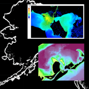
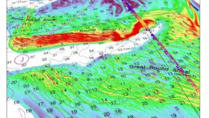
TCarta Marine, a global provider of marine geospatial products, has supplied the National Oceanic and Atmospheric Administration (NOAA) with satellite-derived bathymetry (SDB) validated by green laser altimeter data from the NASA ICESat-2 satellite for two U.S. shallow-water coastal areas. TCarta was the subcontractor on the prime contract awarded to Woolpert, an international geospatial firm headquartered […]

TCarta Awarded NOAA Grant to Enhance Satellite Derived Bathymetry Technology in Alaskan Waters

March 8th, 2021
TCarta Marine

TCarta Marine, a global provider of space-based hydrospatial solutions, has been awarded a Small Business Innovation Research (SBIR) Phase II grant from the National Oceanic and Atmospheric Administration (NOAA). The research focuses on enhancing Satellite Derived Bathymetry technology for application in the coastal waters of Alaska. Satellite Derived Bathymetry (SDB) extracts water depth measurements from […]