By: Chris Ilori
Nestled in the heart of Africa, Lake Malawi, known as the ‘Calendar Lake’ due to its dimensions (365 miles by 52 miles), is a geographical marvel. This third-largest African lake, and ninth-largest globally, is a thriving hub of biodiversity with over 1000 distinct freshwater fish species, 99% exclusive to this unique ecosystem. Join us on an enlightening exploration of the transformative impact of Satellite-Derived Bathymetry (SDB) on Lake Malawi and the diverse waters of Africa.
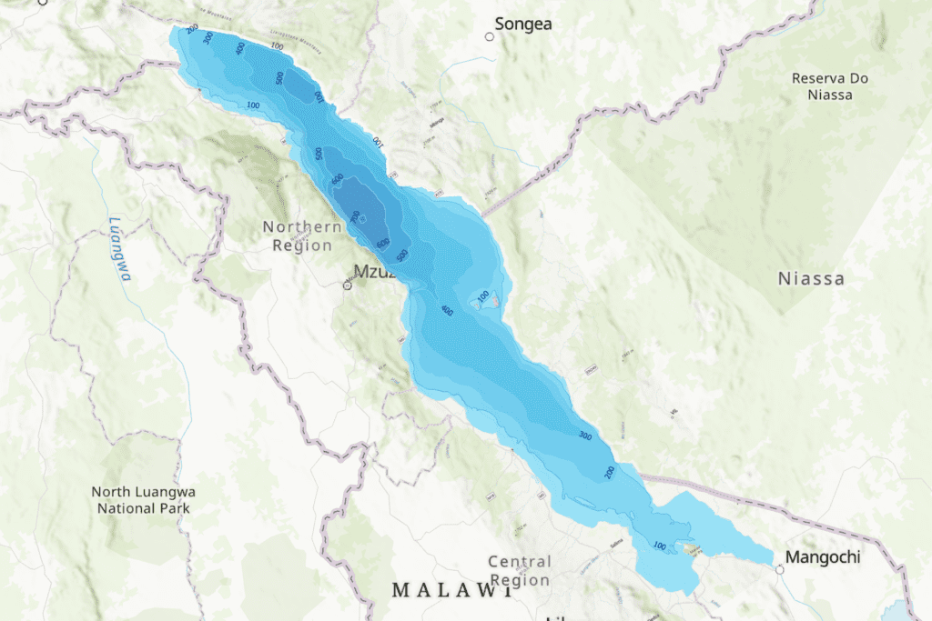
SDB in Lake Malawi: Charting New Frontiers and Exploring Potential Applications
Mapping and Monitoring Shoreline Changes: SDB, with high-resolution satellite imagery, becomes indispensable for mapping and monitoring changes along Lake Malawi’s shoreline. Identification of areas prone to deforestation, bush fires, and poor land husbandry empowers environmental authorities to implement targeted interventions for habitat preservation and restoration. Through change detection, patterns emerge, guiding adaptive strategies for sustainable shoreline management.
Detecting and Mitigating Soil Erosion: Detailed underwater topography obtained through SDB allows the identification of regions vulnerable to soil erosion. Mapping and monitoring enable conservationists and land managers to implement strategies for mitigating erosion, preserving the lake’s ecosystem integrity, and protecting against sedimentation.
Monitoring Fish Populations and Fisheries Management: Addressing the critical concern of fish overexploitation, SDB, combined with fisheries data, contributes to monitoring fish populations and habitats. This information aids in developing sustainable fisheries management strategies, ensuring the conservation of fish stocks for environmental and community benefit.
Assessing Water Extraction Impact: SDB offers a unique perspective on the lake’s bathymetry, enhancing the understanding of the impact of heavy water extraction for irrigation. Assessment of changes in water levels and flow patterns enables informed decisions on water usage, balancing agricultural needs with the preservation of the lake’s hydrological balance.
Beyond Lake Malawi: A Pan-African Perspective
Intercontinental Navigation and Infrastructure Planning: Recognizing the significance of African lakes as critical waterways, SDB data integration extends beyond Lake Malawi. Enhancing navigation safety and contributing to informed infrastructure planning on an intercontinental scale will ensure responsible development along the shores of lakes and rivers across Africa.
Ecological Research Across the Continent: SDB facilitates in-depth ecological research, enabling scientists to study relationships between bathymetry and biodiversity on a broader scale. This information is invaluable for identifying critical habitats, migration routes, and guiding conservation efforts to preserve the natural heritage of lakes and rivers throughout Africa.
Disaster Management: The role of SDB extends beyond scientific exploration and infrastructure planning; it plays a pivotal role in disaster management across African water bodies. SDB becomes an invaluable tool in anticipating and responding to natural disasters such as floods or earthquakes by providing real-time and detailed underwater topography data. This proactive approach allows for better preparedness, early warning systems, and swift response efforts to mitigate the impact of disasters and protect both human and ecological interests.
Proactive Adaptation to Climate Change Effects: The dynamic nature of SDB data transforms it into a proactive tool for adaptation. By continuously monitoring alterations in underwater topography and temperature, SDB offers early indicators of potential climate change impacts on African lakes. This proactive approach allows stakeholders, including environmental authorities and conservationists, to promptly anticipate and respond to emerging challenges.
Celebrating the production of Satellite-Derived Bathymetry data in Lake Malawi unveils its potential for the entire African Great Lakes region. The ‘Calendar Lake’ becomes a gateway to understanding the intricate dynamics of Africa’s water bodies, and SDB can guide us toward sustainable resource management, environmental conservation, and responsible development, aligning with the United Nations Sustainable Development Goals (SDGs). In the vast expanse of Lake Malawi and beyond, Satellite-Derived Bathymetry is not just a technological marvel but a key to unlocking the secrets and ensuring the future well-being of Africa’s precious water systems.
