• Skip to primary navigation
  • Skip to main content
TCarta Satellite-Based Hydrospatial Tech

TCarta Satellite-Based Hydrospatial Tech

We are your contact for Marine Remote Sensing and Hydrospatial data services.

  • Who We Are
    • About
    • Partnerships & Affiliations
  • What We Do
    • What is Hydrospatial?
    • What Do We Measure?
    • How to Work with TCarta
  • Products & Services
    • Products
      • Global Bathymetry GIS
      • Satellite-Derived Bathymetry
      • Seafloor Classification
      • Newsletter Archive
      • Marine Basemaps
    • Services
      • Blue Carbon Mapping
      • Synthetic Aperture Radar (SAR)
      • Satellite-Derived Water Quality
      • Trident Tools Satellite-Derived Bathymetry Software
    • Custom Solutions
  • Case Studies
    • Space-based Hydrospatial Solutions for Engineering Projects in the Littoral Zone
    • Technology Demonstration Project: Large-Scale Satellite Derived Bathymetry Mapping
    • Hydrographic Office Technology Integration
    • Updating Information on Nautical Charts in Baffin Island, Canada
  • News & Press
    • Newsroom
    • Blogs
  • Product Viewer
  • Contact
  • Show Search
Hide Search

capella

Exploring the Frontier of Environmental Monitoring: Utilizing Capella SAR for Blue Carbon

TCarta Marine · August 1, 2024 ·

The Blue Ecosystems and Their Importance

Read on Capella Space

In the quest to combat climate change, monitoring carbon storage across diverse ecosystems is critical. While forests are often in the spotlight for their role in carbon sequestration, lesser-known ecosystems like wetlands, mangrove forests, and seagrass beds are emerging as crucial players in the fight against climate change. These ecosystems sequester carbon dioxide from the atmosphere and store it in their biomass and sediments, making them highly effective carbon sinks offering a nature-based solution in carbon sequestration. Despite their importance, coastal ecosystems are increasingly threatened by human activities, including coastal development, pollution, and climate change. Fast, replicable, and verifiable methods of monitoring these dynamic ecosystems continue to be a significant challenge globally.

Red Polygon indicates current assessed extent by Global Mangrove Watch
Mangrove Health mapping & Classification with Capella SAR

Capella SAR Technology: Transforming Monitoring Capabilities:

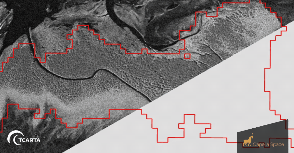
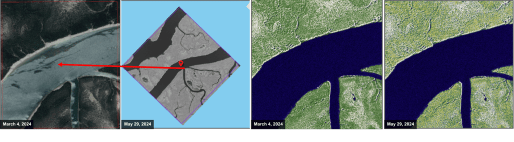
Capella Space, a leader in harnessing the power of Synthetic Aperture Radar (SAR) technology to revolutionize Earth observation, is transforming the possibilities for monitoring  mangrove environments with unprecedented detail and frequency. With Capella’s constellation of small yet agile satellites equipped with SAR sensors, mangroves can be monitored night and day, at an unprecedented spatial resolution. Equipped with Capella SAR, TCarta is uniquely positioned to track changes in mangrove environments at sub-meter resolution.

Mangrove monitoring methods are scalable, global and have little to no limitations in assessing the health and extent of existing Mangrove based Carbon Credits
Marvivo Magdalena — Mangrove Species: Subset analysis of two different mangrove species in Baja California, Mexico.

With Capella SAR, TCarta can provide:

  – All-Weather Monitoring: SAR can penetrate clouds and operate day or night, providing continuous monitoring capabilities even in challenging weather conditions prevalent in tropical regions where mangroves thrive.

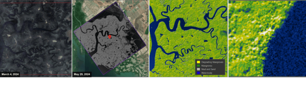
  – High Spatial Resolution: Capella’s SAR satellites capture images with resolutions down to 50 centimeters, enabling detailed mapping of mangrove structure and extent. With the majority of global assessments and datasets regarding mangrove extent at or larger than 10 meters, TCarta offers a solution that is 20x the spatial resolution. This high resolution is crucial for accurately delineating new growth, changes in canopy dynamics, and monitoring changes in mangrove cover over time.

  – Frequent Revisit Times: With multiple satellites in orbit, Capella provides frequent revisits to specific areas, allowing for near real-time monitoring of mangrove dynamics. This capability is essential for assessing seasonal changes, supplementing measurement, reporting, and verification (MRV) of blue carbon assets, and allowing clients a deeper understanding of current and potential blue carbon assets.

Delta Blue Carbon Analysis — Mangrove Health and Extent: Subset analysis of current health and extent in Karachi, Pakistan
Allcot AG — Mangrove Health: Subset analysis of current health and extent in Sinaloa, Mexico

TCarta Innovation:

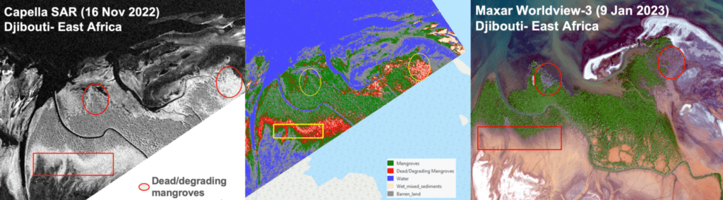
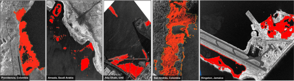
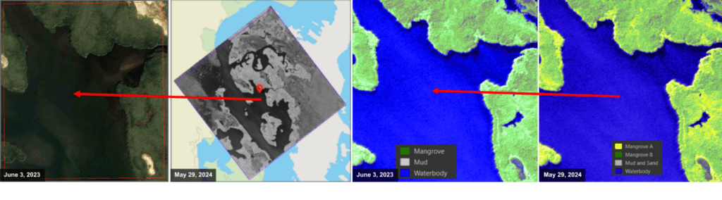
TCarta, in partnership with Capella Space, has developed a precise mangrove detection and monitoring technique using high-resolution SAR data. TCarta leverages SAR characteristics such as surface roughness, texture, and backscatter values, along with advanced processing and machine learning, to accurately map mangrove extent, monitor changes in their health and extent over time, and estimate carbon stocks in mangrove biomass and sediments. This approach supports habitat assessment, restoration efforts, and climate change mitigation strategies, allowing companies to perform their own due diligence when investing in mangrove-based carbon reduction assets.

Back to Newsroom

TCarta and Capella Space Partner to Leverage All-weather SAR Imagery for Coastline Management

TCarta Marine · February 14, 2024 ·

TCarta to use Capella Space’s 24/7, sub-daily synthetic aperture radar (SAR) imagery for detailed hydrospatial analysis

Read on Capella

Capella Space Corp., an American space tech company with data and satellite solutions for government and commercial applications, today announced a partnership with TCarta, a global provider of hydrospatial products and services, to add high-resolution SAR satellite imagery to TCarta’s coastal monitoring and shoreline feature extraction solutions. This partnership will enable more consistent and reliable identification of coastline changes so coastal managers have the accurate and up-to-date information for mitigating the impacts of climate change.

Rising oceans and melting glaciers are quickly changing the geography of the world’s coastlines, reshaping ecosystems and threatening the livelihoods of coastal communities. This is especially prevalent in the Arctic with melting permafrost and sea ice. Understanding the rates and causes of shoreline change can help coastal managers better understand how to mitigate the hazards to local communities and their ocean economies. Reliably mapping coastal features and measuring shoreline change with traditional earth observation technologies can be difficult when having to consider variable conditions like changing tides, darkness and cloud cover. These factors are very persistent in coastal regions and at higher latitudes. TCarta’s innovative technology overcomes these challenges by leveraging Capella’s automated satellite tasking system to synchronize SAR imagery collections to precisely match up with real time tidal fluctuations with minute-based accuracy.

TCarta was as an early adopter of the Capella Space Analytics Partner Program looking to accelerate its research and development efforts with high-resolution SAR to enhance its state-of-the-art hydrospatial models. TCarta is now a Certified Analytics Partner, unlocking a wide range of exclusive benefits for the company which include opportunities for both product and market collaboration and continued access to Capella’s rich imagery archive.

“Being an early adopter of the Capella Space Analytics Partner Program just makes sense for TCarta’s mission to apply space-based technologies to enhance human understanding of and planning for climate change impacts,” says TCarta founder and President, Kyle Goodrich. “The implementation of Capella SAR in TCarta’s coastal datasets means more accurate and actionable information in the hands of our clients.”

“TCarta is a team with unmatched expertise in remote sensing and hydrospatial analysis. We are thrilled to elevate our partnership so coastline managers can leverage the full value of 24/7, all-weather SAR imagery and automated tasking to help mitigate the impacts of climate change,” said Dan Getman, Vice President of Product at Capella Space.

About Capella Space

Capella Space is an American space tech company with data and satellite solutions for government and commercial use. A pioneer in the Earth observation industry, Capella is the first U.S. company with a constellation of Synthetic Aperture Radar (SAR) satellites, delivering the best quality, highest resolution SAR imagery commercially available. Capella provides easy access to frequent and timely information affecting dozens of industries worldwide, including defense and intelligence, supply chain, insurance, maritime and others. Its market-leading SAR satellites are matched with unparalleled data infrastructure to quickly deliver reliable global insights that sharpen our understanding of the changing world – improving decisions about commerce, conservation, and security on Earth. Headquartered in San Francisco, California with additional locations in Denver, Colorado and Washington, D.C.

Learn more at www.capellaspace.com.

Back to newsroom

Subscribe to our newsletter


Loading

TCarta Marine LLC

1015 Federal Boulevard
Denver, CO 80204, USA

+1 (303) 284-6144

TCarta Caribe LLC

26 Haining Road
New Kingston, Jamaica

+1 (876) 817-8567

TCarta Canada Services Ltd.

1771 Robson Street - 1508
Vancouver, BC, V6G 3B7 CA

  • What We Do
  • Legal
  • Contact
  • LinkedIn
  • Instagram
  • Facebook
  • Twitter